Colin and I arrived in Calama and switched to a bus for San Pedro the morning of the 3rd of April. Once we got to San Pedro we managed to find a pretty cheap place (negotiated for 16,000 pesos) – but it was ‘bring your own toilet paper.’ Thankfully, being in South America (where the majority of bathrooms, though not typically hostels, contain no toilet paper at all) we carry it with us anyways.


We started our time in San Pedro by visiting a great museum which provided us with background on the region and its people: the Gustavo Le Paige Museum, named after a Belgian Jesuit Priest who investigated and saved numerous important archeological finds in the region. The first room in the museum was his office, set up as a tribute to him in the original way it was kept. His collection went through the history of the Atacama peoples, starting with their arrival 12,000 years ago.

Much of the area around San Pedro was Puna, or the highland plains 4,000 meters above sea level. This area had its own specific plants and animals adapted to such low-oxygen conditions such as sharp, dry grasses with compacted branches, cacti, desert-adapted lizards and flamingos who get their food from the abundant salt lakes.
The area of San Pedro is an oasis within a harsh climate and altitude for the people of the Atacama, a gorge are where they settled because of its available water supply. It was here the people of the Atacama were able to find volcanic stones for their tools, arrows, and jewelry. This stone was ideal because of its ability to ‘flake’ or be shaped by other stones and refined into objects. The people of this time also used bones from vicuna and other animals to make their tools.


Between 4,000 and 600 BCE the lifestyle of the Atacama people began to change as their camelids became domesticated after they captured infant guanaco and vicuna to raise. Since people no longer had to travel following the camelids from the puna to the edge of the Atacama Salt Flat in the gorges and back, they were now free to grow communities.
The people and their society advanced by maintaining villages and changing their manufacturing. They moved from stone and bone crafts to wooden crafts This most notably happened with their hallucinogen ‘stuff’ tablets and straws. In this museum I saw snuff tablets go from stone and bone, to wood, then eventually to metals such as copper which is abundant in the region.


These metals were used by the Tiwanaku (who contributed numerous trade systems, a unified government, and a universal religion to the region) and eventually the Inca when their Empire took over the San Pedro region. The Incans also were after gold such as the piece below.


Coming out from the museum we popped over to the Church of San Pedro de Atacama. This church was originally built in the late sixteenth century. The church we visited was rebuilt, dating from the 19th century and we admired the cacti wood roof from the inside.

The following day I had a day off, while Colin rented a bike and headed out to see some of the areas which I had already visited during my first time in San Pedro.
------- Colin’s Section------
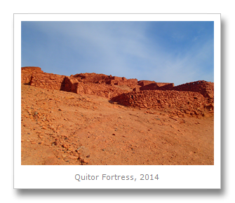
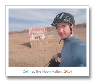
I got up early and headed down to the bike rental agency which we ended up using for all of our tours in San Pedro. The bike was OK, an I got helmet, pump and a map too, so I headed off out of town to make my way to the Valley of the Moon. Francesca had already been there on her previous visit to Chile, so she had decided to stay in town and relax. I got a little lost on the way and so ended up in the place I wanted to go to in the afternoon, the Pukara de Quitor. This 12th Century fort was located 3kms from San Pedro, and was built on the slope of the Salt Mountains to help defend the settlement of Quitor. The 24,000 meter squared fort overlooks the San Pedro river, and was the site of a successful defense against the Spanish in 1536 by the Atacaman Indians. Several years later the Spanish teamed up with hundreds of Yanaconas Indians (slaves they had ‘freed’ from the Incas) and overran the fort. The Atacamans were beheaded and the heads placed on spikes as a warning around the fort. The fort became known as the village of the heads.

The day was starting to heat up, so I decided to skip the long walk up to the mirador which is included in the fort, and instead ride my bike through the desert to the Valley of the Moon. This private reserve is located between two mountain ranges with the Atacama desert: the Salt Mountains and the Domeyko Mountains. Strong winds over thousands of years have eroded the canyons and rocks down to amazing shapes, caves and tunnels, and the underground water flow has eroded lots of caves underneath the salt to form salt caverns.
The whole reserve is a valley that includes several different attractions. The grey, red and moonlight landscapes are what gives the region it’s name – and it is where the moon rover was tested for the successful moon mission in 1969.
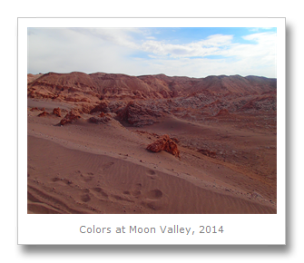


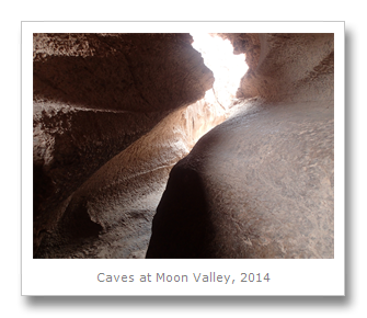
A huge amphitheater and nearby lookout point (very tough to walk to through thick sand at high altitude in the heat) were highlights. By the time I got to the sandstone canyons and caves it was pretty hot, as it was the mid-afternoon, so I took some walks through the caves there, and saw the result of a huge rockslide which I had to clamber over. At the end of the approximate 15km bike ride, I biked the 15km back to town. The whole day I must have gone almost 40km, and it was a lot nicer and cheaper than a tour would have been. I got back safe and sound (take plenty of water and sunscreen), and slept the sleep of the tired.
-------- end---------
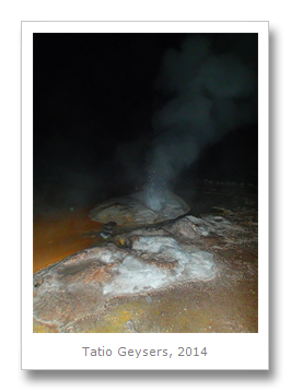
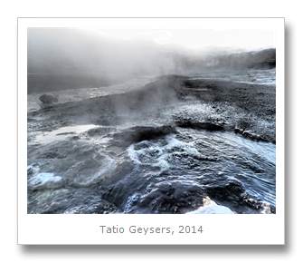
We had to wake up at 4:00 am to make it out to the Tatio (‘Grandfather’) Geysers. Colin and I piled into the van which brought us up to more than 4,000 meters in altitude as we slept in the darkness of the early morning. Once we arrived at the geysers we followed our group through a little pathway, being very careful of the ground as geysers and steam vents are often pretty hidden – indeed, a few places fell away as we walked near them!
These geysers consist of 3.86 square miles of 80 hot springs, mud pools, and geysers. Tatio is the highest altitude geysers in the world at 4,300 meters above sea level. The geysers (which can reach up to 10 meters in height) are formed due to contact between the cold subterranean water and the hot rocks which have been heated by the lower layer volcanic magma. Often the 185 F (85 C) degree steam around the geysers is released through cracks in the Earth’s crust producing fumaroles. We learned that the water flowing from the Tatio Geysers forms the Salado River which, 50 miles on, joins the Loa River.
A few times we stopped and got to watch some of the geysers ‘go off,’ and though none of them reached too high, it was awesome to see so many geysers spread around the same place. As the sky started to brighten we got to see the sun rise over the mountains which connected the area with Bolivia – stunning views! We also enjoyed a breakfast of breads, cookies, teas, cheese, meat, and loads of avocado.
Nearby were a couple of foxes waiting for some scraps. (Which they did manage to get later on.) A few more photos later we drove to an area with a hot water-fed pool where I got to soak my feet. I later found out that Codelco (the state owned Chilean mining company) is actively exploring in the area, digging holes and created inadvertent artificial fumaroles. Hopefully this doesn’t continue, as it would destroy a beautiful natural monument.
Next we drove back to San Pedro through some beautiful countryside where we saw vicuna, viscachas, and flamingos.


In the afternoon Colin and I went out for a delicious lunch of a traditional Chilean cazuela stew – filled with chicken, corn, and other veggies. It filled us up and we had a few hours after to relax before our next tour.

In the afternoon Colin and I went on a tour with Vive Atacama of some nearby salt lagoons. Our tour guide took us to a salt lagoon called Cejar, which is 30% salt. We were able to float around in the lake. There was another salt lagoon nearby, Piedra. During the rainy months the two salt lagoons are connected and serve a host of animals. We enjoyed floating with little effort despite how freezing cold the water was. When Colin and I came out of the water we were covered in salt – even my hair was covered in salt and started to become stiff.


We next piled back into the car and drove to the ‘eyes of salt.’ The ‘eyes of salt’ is a giant sinkhole where water under the salt flat caused the salt to break off and fall into the giant hole of water developing below. Here we watched as people jumped into the water. Since we had just dried off, we declined to go back into the salt water and just walked around the giant pools, looking back at the Andes in the distance.


At the final lagoon, we enjoyed some pisco sours and snacks while our guide played some indigenous songs on a flute for us. On the way back to San Pedro our guide flipped on some ‘party lights’ and mini strobe flashed through the bus as our guide danced for us!


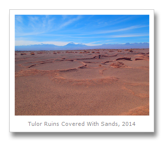
Our final day in San Pedro we rented a couple of bikes and went out to the Ruins of Tulor, which used to be a pre-Columbian Atacameno village. Settlement of the area dates from 380 BCE – 200 CE, though most of the circular mud ruins themselves date from 800 CE – 1200 CE. After we arrived at the ruins and paid our entrance fee, we stopped to have some snacks and refuel a bit after the bike ride out. We then walked around two small museums near the ruins which had a few pieces of pottery collected from the archeological dig of the ruins years ago.
Next – out to the ruins. There was one reconstructed house which showed us what the place used to look like, as most of the ruins is still covered in the sands of the Atacama desert. If it is uncovered (without a proper building or protection over the area) the ruins would be severely damaged. A few of the houses had been uncovered for tourists’ eyes, and I could already see the cracks in the foundation caused by the blazing desert heat. There are no plans to excavate further, unfortunately, nor to provide the remains of this historical town with more protection and because of this the site is listed on the ‘World Monuments Watch List of 100 Most Endangered Sites.’


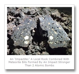
Our final evening in San Pedro we decided to pop over to the new Meteorite Museum where we paid a hefty entrance fee and got to see quite a few interesting meteorites, part of a 3,000 piece collection from its owner who is an amateur ‘meteorite hunter.’
A woman came out to greet us and told us all about the different pieces. She described the three different sections of a meteor: the crust or outer layer, the nucleus or innermost layer, and the layer in between known as the mantle. There were examples of each of these sections of the meteor in the museum. She also explained to us how our current sun is actually the 3rd star in that location – evidenced by how much iron is contained in meteors on Earth. This iron was formed during the supernova of the 2nd Sun. This pure iron is contained in the nucleus of the meteor, and I got to hold a chunk of pure iron meteor in my hand. It was pretty heavy! Some of the meteors we saw contained elements or materials not found on Earth, or not found on Earth in such a ‘pure’ state and it was a unique experience to see them in the museum.


We had lots of different adventures in San Pedro, even with food! We tried a new dish called cazuela. This is basically a soup that has rice, or corn, vegetables,boiled potatoes and some meat lumped in the middle. Looks simple and is cheap, but tastes delicious!

The following morning we took the bus to Iquique – land of earthquakes.
Francesca
No comments:
Post a Comment