Tuesday, January 28, 2014

Volatile Chile


We arrived in the town of Chaitén by bus on 28th January. A short three and a half hours by minibus from Futaleufu, we were happy to see paved roads again. However, we did not quite know what to expect to find, as stories about Chaitén’s status abound on the road. Rumors and backpacker gossip are not helped by out of date guide books proclaiming Chaitén as a ‘ghost-town’. In the massive eruption of the nearby Chaitén Volcano in May 2008, the town itself was completely destroyed. Volcanic tephra (ash, cinders and small super-heated rocks) blocked the nearby Rio Chaitén, diverting it into the town and flooding it with the thick grey ash-filled sludge. In fact, the volcano had not blown for 9500 years, but is now still in an ‘eruptive phase’ since causing mass evacuations across the region. Online reports even state that Futaleufu was covered in a large amount of ash, and it was evacuated also; but we never saw any sign of damage there, and no-one mentioned it all – probably because the Futaleufu residents do not want the fragile tourist industry to be adversely affected with the same type of rumors surrounding Chaitén.

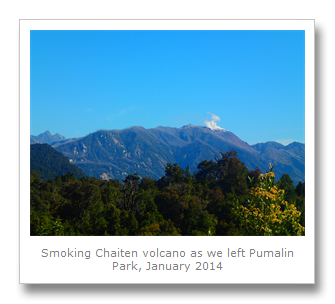
The truth is, as of the 31st January 2014, Chaitén is pretty much on its knees, but it is slowly starting to stand again. It has functioning services, like numerous residencial and hospedaje accommodations, a tour agency (Chaitur Excursions) and supermarkets. On the whole the volcanic ash that covered everything has been cleared away, and the roads are good, the ferry port across the Corcovado Gulf is working (infrequently) and it is almost business as usual. Before the explosions, there were about 4000 people, but now there are less than a thousand. Many houses stand vacant. With broken windows and heaps of ash in the front yards covering vehicles that were in use up until the volcano clogged their engines and everything else, they serve as a reminder of how close the town was to being wiped out. The volcano is visible on the rare days when the clouds lift and the rain stops, with its 3km wide lava dome still pouring it’s lethal gases all across the sky.

We had expected to arrive much later due to the state of the roads we had been on, so we unexpectedly booked on a tour of the Pumalin Park private nature reserve next to the town. We had barely enough time to get some food, and store our bags with the the agency – the aforementioned Chaitur Excursions before heading off again for a full day in the reserve.

Located to the North of Chaitén, the Pumalin Park reserve actually contains Volcano Chaitén along with Volcano Michinmahuida. The park was closed after the eruption for over two years until late 2010 whilst they affected a safe clean-up, further adversely affecting the economy of the region. A huge fault line runs under the two volcanoes, which also produced some minimal earthquakes in 2005, a precursor of the destruction to come.

Our first stop was to see the Volcano Chaitén Trail, or at least the first twenty minutes of it. It was a rare sunny Chaitén day, and the first thing that struck me was the large number of horseflies around. These annoying huge flying currants actually bite, so I killed as many as I could whilst I was there.

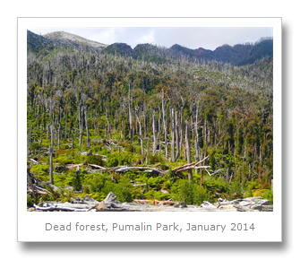
The trail runs through some Valdivian rainforest which had no large trees. After about ten minutes, the trail opened up and we could clearly see why the trees were missing – the volcano had left a huge trail of destruction all over the mountainside. Hundreds, perhaps thousands of trees were just grey stick-like dead things sticking out of the ground. One side of one mountain facing away from the volcano was covered in verdant and lush rainforest; it’s other side, facing the volcano, was grey death.

The eruption started on May 2nd 2008, and evacuation of all but a few hundred stubborn residents was completed by the next day. Water supplies were completely contaminated by a 30 mile high plume of ash landing down around the region. Satellite photos show the ash reaching across the continent, pushed by the Pacific winds all the way to the Atlantic Ocean. On May 6th, the volcano completely exploded, sending pyroclastic flows down the side of the mountain, which, when mixed with the nearby river water, created lahars (volcanic ash mixed with water creating thick, sticky mudslides). These lahars clogged up the rivers, which subsequently killed the trees and destroyed the town. The tephra was extremely hot, and the cinders burnt vegetation and trees alike. It was amazing to see such devastation, especially caused so recently. After about half hour, with the guide explaining everything in Spanish, we moved on. Francesca and I resolved to return to the trail and go up to the crater, from where you can stand next to the smoking volcano caldera itself.

The next stop was a short trail leading up to a set of beautiful cascades in a steep-sided narrow canyon. The other members of our tour groups were a Chilean family with children, and some other backpackers on their own. It was a fairly easy tour to go on, and very diverse, helping showcase the natural diversity of the park itself.

Our next stop was a big draw for many people – the Alerce Trees Trail. We had previously visited Los Alerces National Park in Argentina where we had seen two small Alerce trees, and this was our opportunity to see some of the oldest examples of this tree on the planet!

The trail was very easy, with lot of wooden stairs and handrails to help over the forest floor. Eventually we came to a grove of really old Alerce (Patagonian Cypress) trees. These bigger specimens were extremely impressive – much more interesting and awe-inspiring than the smaller ones we had seen in Argentina. There were numerous trees here, and it is really good to see that over 80% of the Alerces here survived Volcano Chaitén. At the end of the trail there were even some clearly over 3000 years old. Over 60 meters tall, these are some of the largest trees in the world. The oldest Alerce was 3622 years old, which made it the second oldest tree in the world, verified by counting the rings of the trunk.

It was amazing to see how different this ecosystem looked compared to the ones just down the road in Futaluefu, Puyuhuapi and Coihaique. The colors, shapes and mixture of the trees are different in each area – it made Francesca and I realize how important it is to protect these areas as National Parks from further exploitation.

Pumalin Park is the largest privately owned park in Chile (3250 kilometer squared), and is operated as a free access public park based on sustainable touristic and economical values. Opened in 2005, it was donated by Doug Tompkins, an American tycoon who has caused lot of controversy by buying up large tracts of land in Argentina and Chile and turning them over to the government as protected areas. He was the co-founder of outdoor equipment and clothing firm The North Face and Esprit respectively, but sold it all off to become the environmental philanthropist he is today. He also owns the private reserve in the North of Argentina we saw a little of; the Iberá Wetlands.

There are many who do not want Doug in Chile at all. There was widespread panic over his accumulation of so much land. Politicians and business have exclaimed that he has ‘divided our narrow country’, as the park stretches from the West coast to Chile’s Eastern border with Argentina. The anti-Semitic military have claimed that it is a Jewish conspiracy to stop Chile from progressing. In reality, it is really just the logging and hydroelectric companies who have a problem with Tompkins, mostly concerning his activism against those same companies who have polluted rivers and destroyed huge parts of the rainforest already. Doug Tompkins apparently spearheads the anti-dam movement of Patagonia sin represas.

In the afternoon we had finished our Alerce Trail walk and all got back in the minivan (away from the hideous flies), and trundled along back to another, bigger trail called Cascadas Escondidas. There was one of the park’s numerous campsites here, and we stopped to eat our lunch. Francesca and I had packed some empanadas (including an apple empanada!), cookies and chips. The flies were still really annoying, but the weather remained good, and lunch was nice.

Afterwards we started heading up. And up. And further up. Up a large number of wooden steps, we reached a turning point and went right over a rickety looking wooden bridge. We eventually came to steps leading down. This came to a beautiful opening where a twenty meter waterfall was crashing down into a hidden pool surrounded by huge cliffs.

Back up, and there was another longer trail to the higher waterfalls. These were a little further away, but still pretty impressive – and the spray from it cooled us down after the hot and humid walk up hundreds of  stairs.

We got a little lost on the way back down, and ended up going past another Alerce Trail on the way back to the vehicle. Luckily, everyone was much slower (must be all the hiking practice we have been getting), and so we waited with the flies until we could get out of there!

On our way back to town we got to stop at a lukewarm natural thermal spring  right by the side of the road – but it was pretty yucky from all the plants, so we never got in it. Then, we made another unexpected stop (Francesca and I jumped on the tour without checking what else we were to do) at Santa Barbara beach, between the park and Chaitén town. This volcanic sands beach is completely black, with lots of kelp over the rocks, and a few people dotted here and there, some camping, some cooking, some drinking, some just relaxing.

The brutal flies at this time of year meant we did not want to do any of these things for too long, so we got another empanada from a house near the beach and then all returned to the town.

Francesca and I found some accommodation and then picked up our bags from the agency office. It had been a full and totally unexpected day, but it was a diverse and great tour – well worth the $US40.

We soon found out that our ferry was not available for a few days, so we made the most of hanging out in the town. The place we stayed in was OK – we had learnt not to interact too much with the old ladies who run these hospedajes. The less interaction, the less chance of a falling out. The town was pretty basic in what it had to offer when we were there, but it was comfortable enough (we managed to get our laundry done, etc.).

On the 31st January we decided to revisit the volcano and get a closer look, so we walked to the edge of town (after buying the essential empanadas) and tried our hand at hitchhiking. Luckily we got a lift after about 10 minutes by a tour that was going to the volcano from none other than Chaitur Excursions. We got out at the start of the trail and told the guide we had decided not to do the tour but thanks for the lift. I tried to give him a little money but he was still keen on getting us to come back with them so told me he would take us back when we had all finished for half price. We ended up paying nothing because they were much quicker than us and left before we got back down.

The trail was better than before because the bad weather had chased off all the horrible horseflies that had pestered us last time we were there. Dead trees were everywhere, trunks burnt to a crisp and now just hollow grey shells. The grey ash was all over the floor everywhere, and as we went further up and up towards the volcano itself the ash turned to stones which turned to bigger and bigger rocks the higher we went.

The first kilometer was an easy and relatively flat walk on an easy trail, but after this it started uphill with hundreds of stairs that they had added. It was a climb of over 600 meters along a trail of 2.2 kilometers so it was pretty steep in places, especially near the top.

The view was pretty incredible on the way up, and we saw a huge swathe of destruction that ran down the hill in three directions all the way to the river. All the trees in the path were dead, either burnt by the hot pyroclastic flows, or knocked over completely. Rain started heading our way from the Pacific and we could clearly see it falling a few kilometers away over the land, but we were lucky as we never got wet because it turned away at the last minute.

The last forty meters or so to the top were pretty difficult and scary. One lady gave up, clinging to the ground as if the mountain might collapse all around her! We persisted, and followed the ridge up to the top across loose ash and gravel from the volcano. It was worth it. We had seen the lava dome on the way up, but when we got to the top of the walk we could see it much better. Sitting in the three kilometer wide crater on top of a caldera of burning molten lava, the lava dome is red and black ash and rocks, with numerous fumaroles of smoke plumes springing from all over it.

The bottom of the crater, between the mountain and the lava dome was just grey ash with lots of deep ridges that would make it hard to cross – but that was 50 meters below us. We could clearly see where the volcano had exploded through the side of the mountain right next to us back the way we had come from.

At that moment, once everyone else had left the top, the clouds parted and we got some good picture with the sky really blue. It really contrasted the reds and black of the lava dome, with the white smoke pluming from the top. The surrounding forest was doing its best to return and the greens added to the strange beauty of a terribly dangerous place. If the volcano had blown then, we would have had little chance of escape – although hopefully it might have given us some warning before erupting fully.

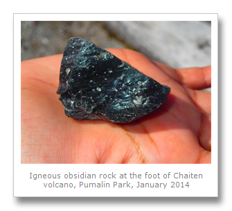
The obsidian at the top of the volcano was much bigger than the smaller lumps we had seen at the bottom of the trail – and we even a Chilean hawk, which I got some snaps of.

This was our first active volcano that we had climbed – and it was a difficult climb (especially down – the knees really need help from trekking poles) – but it was totally worth it. There is no fee to enter this park either, and as we got a hitchhike back within twenty minutes from some local in a jeep, the whole visit was free.

We got back to Chaitén around 7pm, and got some food. We were due to leave the town the next day, but both enjoyed our time there. Maybe we had simply learnt how to be around the people on the Carretera Austral. Whatever it was, we hope Chaitén gets to rebuild where it is – the Chilean government have announced their intention to help this happen after a movement to stop the town from being moved elsewhere gained momentum after the people marched on the volcano as a protest!

If you do decide to climb Volcano Chaitén, make sure you pay it respect. It is a difficult climb in places, and I am surprised to find no history of unfortunate incidents online when looking at it. Good luck to Chaitén –the volcano is still active, and perhaps the mountain Gods still need to be appeased.

Sunday, January 26, 2014

Futaleufu Sin Represas!


We arrived in Futaleufu the morning of January 26th, deciding to immediately sort out our rafting trip for the following day. Having decided to go with on a full day trip (20 kilometers from Azul River to Futaleufú River) with Patagonia Elements, we stopped by their office to arrange our trip. After that we had the rest of the day free so we took some time for two of Chile’s pastimes – a rodeo and a completo!

On the morning of January 27th we headed down to Patagonia Elements  for our rafting trip. Let me give you a little background on rafting in Chile.

In the 1980’s there was a river which was known as one of the best whitewater rafting areas in the world – the Bio Bio River, named for the singing of the Fio Fio bird by the Mapuche language. The Bio Bio River is the widest river and the second largest in Chile, which is why when the power company Endesa (formerly Chilean state-run, now 60% Spanish-owned) was looking for hydropower, they chose that area for construction of the Pangue dam. While the dam’s construction was halted in Chile’s legal system, it was eventually decided that the water rights of Endesa took precedence over the water rights of farmers downstream who had sued.

The Bio Bio River had historically served as a borderline between Mapuche and Spanish territories. Many indigenous decedents of these Mapuche (known as the Pehuenche) were still living in the area when the Pangue dam was constructed; its construction displaced them despite their fight for their land. In fact, in an article published just one month ago I read that the body of Mapuche Indian leader Nicolasa Quintreman had been found floating in the Lago Ralco reservoir – a reservoir she tried to prevent in a public fight against Endesa.

The building of the dam also ended great rafting on the Bio Bio.
 

Class 5 Rapids on the Bio Bio Before the Dam


Mining in Northern Chile (the mine’s energy requirements consume 37% of Chile’s energy) has led to Endesa looking to build five additional dams by 2020 on rivers in Patagonia including the Pascua and the Baker River in a project called HidroAysen. These dams would effectively end rafting and kayaking on the Futaleufu in the next 5 to 10 years, which brings 80% of the tourism to the city of Futaleufu. It is evident how important the river is in just the city’s name – which means “big river” in the Mapuche language.   

When Colin and I got to Patagonia Elements’ headquarters we saw the rafts we were to be using, which were being loaded onto ramps which the cars would carry to the river. The company came across as professional and we felt very secure even to raft class 5 rapids as the guides had more than 15 years of experience and we were bringing two kayakers with us as safety, along with another manned safety raft or cataraft. I’ve been white water rafting before, but not with this level of safety so it was great!

Colin and I got in the van and we headed off to pick up 3 more people, a German family camping nearby. The rafting trip was underway! Once we got to the river we got into our wetsuits and lifejackets. There were even little boots for our feet, windbreakers, and helmets to protect us from any rocks! Set in our new uniforms we headed down to the raft.

The beginning of the trip was along a relatively flat area where we were able to learn some of the skills we’d need during the trip. We learned that while our guide Christian could steer the raft to the left or right, he could not control the speed we’d be traveling at – that was our job. Some of the commands were easy – “forward” or “back paddle” were self-explanatory, although Christian did note that we should use our whole body to row instead of just our arms to prevent exhaustion.

A few of the commands were a bit more tricky, such as the ones which balance the boat to prevent it from flipping. If he called for an “over left,” those sitting on the right-hand side of the boat would have to move quickly to the left side and grab on to the rope, in fact, everyone including those sitting on the left had to hold the rope. An “over right” was the opposite move. Since Colin and I were sitting on the left, this mean we had to throw ourselves on the right-hand side!

We also learned how to keep the group in the boat. Christian might call  for us to “lean in” (lean in to the center of the raft) or “get down” (get all the way inside the raft) which would be a move executed when a particularly big wave of water was at risk of causing one of us to be a “swimmer” or end up in the water!    

If we did end up in the water (which was quite possible on a river with class 5 rapids!) we had plenty of people around to keep us safe. If swimming back to the raft didn’t work and we were swept away from the  rope there were 3 people who could help us – 2 kayakers and 1 safety  catamaran-raft or cataraft. The kayakers were young super skilled guys in 1 person kayaks which seemed to be attached to them like they were half-dolphin. They moved quickly and expertly – and they were ‘surfing’ the waves in front of us sometimes doing Eskimo rolls in the water. If we reached one of them, there were handles we could grab onto and hold, pulling ourselves onto the kayak with half our body. If we ended up past the kayakers somehow, there was then a cataraft which was much larger than the kayaks so that it could hold everyone just in case our main raft flipped. But we hoped this wouldn’t happen today!  

Our new techniques down, we started the main part of our trip. We began rafting from the Azul River to the Futaleufú River in the map you can see below. Starting in the center of the map, we rafted to the left down all those rapids marked by different grade colors. Yes, we rafted all those class 4 and class 5 rapids you see! My first class 5 rapids, and  impressively, Colin’s first time ever rafting as well. Christian took little videos of us as we road the rapids – I’ll post some of those here to show exactly what we encountered!    

While the river started off slowly, once we hit the rapids they kept coming! Almost immediately we were thrown into a Class 4 (very difficult long rapids with high waves and dangerous rocks) called “Asleep at the Wheel” and a Class 5 (extremely difficult and violent rapids and currents with an extremely obstructed riverbed) called “Terminator” which tested our new skills. At one point we got stuck near a rock and had to complete an “over right” so the boat could get free! Christian had explained to us that sometimes the boulders in the river can created “holes” (like the one in the photo below on the left) in the river which is where the river flows back on itself. These are extremely dangerous because if you get stuck in one the raft can easily flip and the current can drag you into the hole which would create a violent stop – causing damage. We listened to Christian’s directions and made sure to avoid the hole! My favorite rapid of the day was a Class 5 called “Himalaya” which threw two massive waves at us and spun the raft around 180 degrees! It’s all on video!

Class 5 rapid called “Himalaya” on Futa River, 2014


After these tough rapids we stopped for a well deserved lunch which was some yummy pasta salad, sandwiches, and lots of other snacks like cookies and peanuts. Carbs for the next set of rapids!  

Back on the river we got to really enjoy the absolutely stunning scenery around us for a while. We saw some bright blue kingfishers and Colin spotted some mammals along the river. It all seemed pretty easy until one of the main Class 5 rapids called “Mundaca” which was more challenging! The best of all came at the end section of the river though. There was one part before a rapid called “Casa de Piedra” or the “Stone House” where Christian said he had to scout ahead to see what we were up against. The water level that day wasn’t too high or too low – medium seemed to be perfect and our rapids were challenging but not too dangerous. What made this rapid tough wasn’t the water though, it was the rocks! It was a very “technical” rapid meaning that if you didn’t get the angles correct you could end up in the water very quickly. Thankfully we managed to stay in the boat – even if we had to “get down!”       


Class 5 rapid called “Casa de Piedra” on Futa River, 2014


Once we reached the end of the river we saw our car waiting and got changed out of our wetsuits. But not before giving a final word on how much we enjoyed the day. Colin and I took a few last photos of the river (which was flowing so fast; we couldn’t believe we had just rafted down it!) before heading back with everyone for a beer together at the office in town. We waited for our videos to be prepared while hearing stories.
 

Francesca and Colin after Rafting the Futaleufu River, 2014


Futaleufu River in Chile, 2014

If the dam proposed by Endesa moves forward and is built (which looks likely considering the close – many would say corrupt – ties between the politicians of Chile and its shareholders) rafting the Futaleufu River as we had just done will only be possible for the next 5 to 10 years at the most. There is a movement called Patagonia Sin Represas which is fighting against the dams in Patagonia which many have involved themselves in because of the environmental damage which will result from the building of the dams. Colin and I witnessed the color change in the water around General Carrera lake (from a beautiful blue to a murky brown) due to the mining damage in the region – I can only imagine the further damage to the environment if dams make their way all over Patagonia.

Francesca

Tuesday, January 21, 2014

Puyuhuapi


On the 21st January, we traveled the 225 kilometers from Coihaique to Puyuhuapi North along the gravel road of the Carretera Austral. The bus was a combi, or minibus, and was extremely full. Making a few stops along the way, it stayed that way the wh0le journey – which twisted, turned and bumped around so much it made us both car sick.

The scenery changed pretty quickly from the snow-capped mountains surrounding the Rio Simpson that passes through Coihaique, to the lush temperate Valdivian rainforest that would look more at home along the banks of the Amazon than it did in Southern Chile. Huge leaves from Chilean rhubarb, alongside ferns and 50m high trees nestled in valleys and mountainside, topped by craggy granite mountains with snow and glacial waterfalls all around.

The bus finally made it to Queulat National Park and from there shuddered and jerked along the road that sat next to the Puyuhuapi Channel. This channel runs some 120 kilometers from Puyuhuapi in the North, past Magdalena Island (home to a famous penguin colony of Magellanic penguins), all the way to the Pacific Ocean. It seems no-one agrees on the origin of the name Puyuhuapi, but it is probable it is Mapuche for ‘small fish island’.

Founded in 1935 by German immigrants who fled their homes in Czechoslovakia to avoid the coming war, the town started from literally nothing. The Germans, led by Otto Uebel whose name is honored on the main street of the town, burnt the rainforest away to make clearings, before constructing distinctively styled, and German influenced, houses. Eventually more and more people started to come, especially from Chiloe Island to the West, mostly to fish, and build boats. When we were there we saw a salmon farm in the sound, and the local fish dishes were excellent.

On arrival we set about looking for a place to stay and found a lovely hospedaje, which is pretty much the only type of accommodation we have found down here. These are houses bought by locals (or migrant Chileans from the North hoping to cash in on the swelling numbers of tourists) and transformed into very basic hostels, with one shared bathroom. The houses are sometimes decorated to give a very homely feel especially as the owner and family often live there still! Sometimes these are very friendly and welcoming, and other times very uncomfortable and horrible, but you never know until after you check in. The one we stayed in in Coihaique was bad, but happily the one we found in Puyuhuapi was very nice, and was a great place to stay thanks to the family who lived there. Named after the road, Carretera Austral Residencial (why they did not call it Carretera Austral Hostal I will never know), right next to the bus stop, was about $US40 a night – but budget travelers could pick up a cheaper deal down the road. Francesca and I found one place for $US20 but we already liked our place too much because the people were the first friendlies we had encountered for a while.

We showered, relaxed and got some laundry done, then we went to a little restaurant and both shared a plate of grilled salmon, with lovely vegetables and boiled potatoes. Delicious and healthy!

The next day we walked around a bit, learning about the town’s history from information boards dotted around the town. The lady at the tourist information was vaguely useful but you have to really work for the information. We headed off to a carpet factory which has been open since 1945, but as it was closed we stopped off for lunch instead and this time shared a fried hake and chips. The fish was definitely the best food in the region and very flavorful.

The main attractions in Puyuhuapi were located South of the town, back down ruta 7, the way we had come in. The Queulat National Park and two hot spring spas attracted all the attention from the tourists who visit. We decided to save our money and not visit the hot springs, but instead to focus on the park instead. One hot springs was across the Channel and they pick you up n the boat and take you across. The attached hotel was expensive, but if you visit the spa there it would still work out to be something like $US50. The other spa was a more reasonable $US14 each (7000 Chilean pesos), but its hot spring pools were outside and it was freezing cold, plus, we had no transport to get there. That and the fact there were numerous, more easily accessible springs in the North, made up our minds to save our cash.

In fact, we would probably need all the cash we could get our hands on, as there were no ATMs between Coihaique and Chiloe Island that accept international VISA (only MasterCard), and we had numerous stops between the two places, and not everyone takes VISA in this part of the world. Transport was also a massive issue on the Carretera Austral. We should have rented a car in Coihaique, but due to the fact it is quite expensive to drop it off somewhere else in the North, we opted for buses. Buses only run certain days, and at retarded times. The two buses to the National Park and the thermal baths both run at 6am in the morning, so it was on one of those that we tried to get on.

On the 23rd, we were two of fifteen people waiting to get on the small bus that was heading South from Chaiten, in the North, through Puyuhuapi, and through the National Park to the South. Once the bus arrived it was all too clear that there was room for only two or three people. It is illegal for people to stand on these buses, but that was not going to stop the group of three Israeli hikers who were also waiting, from getting on. As soon as they piled on, I grabbed Francesca and piled on behind them, and then so did everyone else. The driver, seeing an opportunity to charge us all for tickets and simply pocket the cash, let us on with only a few grumbles in Spanish. As there were no policemen awake in the police station opposite, I think he decided that there was very little risk getting caught.

It took an hour and a half to get to the South of the park only 50 kilometers away; to the first walk we had decided to do. This was the highly recommended Bosque Encantado, or Enchanted Forest trail. There were so many hair pins and switchbacks on the road that the bus had to travel at just under 25kph the whole way! However, once we got there, the three Israelis and Francesca and I all got off and began into the forest. We were extremely lucky with the weather (the previous day had been raining pretty hard). But that day, we lucked out with plenty of sunshine, and only a few very light sputters of rain.

Francesca and I soon found ourselves alone, and we saw that the trees here were covered in mosses and lichens a deep green. It really looked enchanted, like something from Lord of the Rings. Coihue (beech) and tepu (myrtle) trees, surrounded by ferns, Chilean rhubarb, red fuchsia bushes and bamboo were all shrouded in low-lying mist and clouds from the Pacific, whilst glacial emerald green and crystal clear rivers flowed through it all.

The trail was soggy and muddy, but well looked after. We saw a few bits of trash (come on people!), but on the whole this trail was one of our favorites, as it was so unique and beautiful. After an hour or so, the trail began to climb up, mostly with little wooden planks, handrails and stairs that had been added due to the heavy rainfall in the area. Another hour and we arrived at a fast-flowing river littered with boulders and large rocks that we would have to cross. After our previous walks we had no problem with getting our feet wet – we knew they would quickly dry. We crossed and continued up a slightly steeper incline, when we saw the Israelis coming back down. They told us there was a good spot under a rock to sit down at, at the top. We got there, and were both surprised and delighted by a glacial lake that was cradled by snow and ice-capped mountains in a circle around it. Ice had fallen and formed icebergs in the lake. It was also covering the mountain slopes next to the blue-green lake. We were completely alone. Bliss.

We ate our lunch (whilst I worried about pumas needlessly), and the clouds parted and the sun came out giving us an excellent view of the previously cloud-covered peaks. We could now see the glacier at the top, with multiple waterfalls pouring off of it. Timing!

It was a lot easier to walk back than to get there, as most of it was simply back downhill. No walking poles were needed for this walk though, and going back we could see back down the valley we had come from. It was filled with lush trees and plants with the flowing river we had crossed right in the middle of it, and the forest bordered by the mountains. The snow seemed really close, and it would not have taken much to reach it, or to start climbing up. This walk would have been hell if a storm hit though, so we were again very lucky with the weather.

It took us about 4 hours to do the whole trail – there and back, and we stopped for lunch at the viewpoint. The maps all say three hours, and the trail sign says 2 and a half hours, but it is unclear if they mean to get to the viewpoint or get there and back. Give it at least four hours if you like taking pictures and want to stop for a snack at the viewpoint.

Back at the road we knew we were relying on a hitchhike to get back North to the main entrance to the park where there was another walk we wanted to do. It was midday and there was no bus until 6pm. We waited for some other hikers to return from the walk who we had passed on the our return down the trail – we saw their 4WD jeep parked at the entrance. However, on their return, they said they were going in the other direction.

We got a hitch after just 45 minutes in the back of a 4WD jeep – it was pretty cold, and the winding road took about an hour and a half to go 30 kilometers. It will be great once they pave the Carretera Austral. We saw the park come into sight, and from the road we saw for the first time the park’s centerpiece – the Colgante hanging glacier.

Chile seemed just as merciless to foreigners as Argentina was – it was $US4 for Chileans, but $US8 for us to enter the park. We were going to pay for our Chilean jeep driver and his girlfriend, but when we saw the inflated prices we decided against it…

They did not give trail maps out at the park, so make sure you get one in Puyuhuapi. We paid the old guy at the entrance and made our way to the trailhead going to glacier. The entrance is a 2 kilometer walk from the road, and the trail is another 1 and a half from the entrance, so it is best to remain in the vehicle that gave you a lift if you hitchhiked!

Passing a dozen campsites (literally), we finally walked through the car park to the trail entrance. We crossed a wooden suspension bridge, across the flowing river, and began our walk. Like the first walk, it is all uphill going there, and downhill coming back. Not as muddy, and with no river to cross, at least our feet did not get too wet again – although there was a tricky bit which followed a narrow stream at the bottom of a cliff where we had to avoid treading in any deep water, or twisting an ankle.

A young trio of hikers we caught up with pointed out my favorite sight of the day – a cute, tiny long-clawed mole mouse. He was brown, furry and with a small tail. He did not respond to anything, as he was clearly blind and almost deaf. He was a very young one, and when he ran off he fell of a step and landed on my foot. Luckily he was OK, and disappeared off into the forest.

We also saw lots of chucao birds, which are by far the bravest birds I’ve ever seen! They are little fat things, with a beautiful red chest, and seem to spend all their time hopping around rather than flying. One even investigated my shoelaces, and attacked my trouser leg.

This walk took us just about two hours to get to the viewpoint – which was a nice, but busy (lots of people vying for photo space) view across the lake to the glacier. We had seen pictures of it, and it seemed to have receded rather a lot, which is worrying. It did not quite hang over the mountainside as it once used to. The waterfalls coming off of it and crashing down onto the granite cliffs below were still splendid though. We both agreed that the first walk was better, but it was worth doing both if you have the time.

We got back (the walk back would be much easier with trekking poles) down the steep stairs and rocks, which played havoc with my knees. Once back at the car park though, we managed to jump in the back of another 4WD jeep and get a lift back to the road. There were several different groups of other hitchhikers (mostly Israelis) at the road, so we did not hold out much hope of getting a lift.

It was only an hour until the bus was due to come, but they are almost always full whichever direction you want to travel in. Luckily, the lady who gave us a lift to the road came over and asked me if I would help her in return for a lift back to Puyuhuapi. Francesca and I walked over to the back of her house where she directed me and a guy from CONAF (the park rangers) to move a huge heavy diesel engine about 10 meters. Once that as done, and the engine had sputtered and choked into life, we waited about fifteen minutes, and her family gave us a lift into town.

The road is so bad, that even on the way back it took an hour and a half to go 20 kilometers. This was mostly due to the twists and turns, but also because they are widening the road, and so we had to wait whilst a digger finished some work with rocks crashing down onto the road ahead.

Phew! A full day! Once we were back in town, we showered and relaxed, as we did the next day. We had bought some nice ham and cheese from the small mini-market shop, and we also bought a fried hake with chips again to share. We had asked several times if we could buy onward bus tickets only to be told that it is a bus which cannot be reserved.

Transport is a real problem down here – the morning after we went to the park I woke up early and so decided to look out of our window to see how many people were trying to get the bus after the problems we had had. I was surprised to see a group of four backpackers and the driver fighting! Three guys with backpacks were separating the driver and another backpacker! I guess the driver had told them he was full. The driver left and it seemed no-one had got on. Ten people were all left by the side of the road. However, 45 minutes later another bus arrived, and they all got on it! No-one had even told us about another bus. Changing schedules, different bus times and number of buses each day, all with different number of seats (all small buses though that cannot fit more than about 25 people on them), make for challenging travel. If we opened a business down here we could really clear up!

We checked out on Saturday morning, hoping for a spot on the twice-weekly bus that goes North to Chaiten. We were due to get off it at a small hamlet called Villa Santa Lucia where we wanted to get another connection to a town called Futaluefu, famous for its river rafting.

First, we visited the carpet factory which had been closed a few days before. There was not much to it, but we learned how the factory operated an saw some of the vertical looms that they still use to make carpets for tourists. We did not buy one, but you can give them any design and they can make the carpet for you.

What was really amazing to me was the effort that goes into making these things. It takes three and a half weeks to make a carpet an ship it out, with 20,000 individual knots hand-tied into each square meter! Tiring.

Once we were done at the factory, we made our way back to the hostel to get our bags and we left. We were right next to the bus stop (a restaurant) where the bus was due to leave for the North (you could not reserve tickets, an the bus time was given to us as between 1pm and 2pm). At 2.30pm the bus finally arrived, and the driver refused to let us on at first, because we were only going part way and he wanted someone to get on who would pay the full fare to the end of the line. What a prick. We edged our way on however, with the driver telling us he only had one seat left, and after getting him to write two tickets, and paying him, there was no way we would be getting off.

We left with seven empty seats and continued up the desperate road that is the Carretera Austral. At La Junta we stopped to find about a dozen people trying to get on. The driver was extremely rude to these people saying, in Spanish, ‘It is your problem, not mine’. What a prick. We left, again, with one spare seat because the driver could not get it together enough to fill his own bus, and we left the other travellers to their hitchhiking hell.

We got to the turning at Villa Santa Lucia where we would leave the Carretera Austral and the bus driver from hell, and we were told a bus from the North was coming in ten minutes. An hour later and it actually turned up! We had been debating with a few other people who had got off the merits of hitchhiking, but one French guy told us he had tried all the previous day with no success. Of course, the bus to Futaluefu was full, so we had to get another bus (a small minivan is what passes for buses down here), and go half the way instead which is what we did.

Now in Puerto Ramirez, we decided to call it a night. We had travelled 7 hours and made it from Puyuhuapi to Puerto Ramirez which is only about 140 kilometers. Depressing. We stayed at a horrible little woman’s hospedaje on the junction which I would never recommend to Hitler let alone anyone else. It was expensive, with bad food, and an owner who was rude, obnoxious and greedy. She did a really good job making us all feel really unwelcome (Francesca, me and French Guy had decided to stay at the same place). We left in the morning, and tried hitchhiking, as the bus was at 3pm and we figured it would be full anyway. Francesca went back to the hospedaje owner’s place and asked to use the toilet. The woman screeched at her that she had to pay a dollar to use the toilet, even after we had just spent $US64 on the room and a plain dinner. When Francesca asked her to clarify the amount in broken Spanish she slammed the door in her face! I advise against staying there – it is the only place on the junction in Puerto Ramirez to Futaluefu and Palena…

People seem to take great delight in telling you their bus is full, or that you have to hitch in this part of the world, and the locals really take advantage of the visitors who get stuck out on the road. Once the road is paved and real hotels who provide service and competition to the local knuckleheads out there, all of them will go out of business and be swept away for good. We hope. Francesca and I would totally recommend only doing the Carretera Austral with a car rental from either Puerto Montt in the North, or Coihaique in the South.

After three hours of trying to hitch and no-one stopping, we finally got lucky when a young couple stopped to help us out. French Guy was left on his own, as he had gone to the minimart to get food or cigarettes, but he was OK as we saw him later in town.

We zoomed off to Futaluefu, grateful we were no longer having to deal with this horrible road. There has been some great scenery along the way, and some really nice people, especially in Puyuhuapi, but hiring a car is the only way to travel down here. The greedy and jaded locals were bought up in a different era in a place where they had no contact with visitors until the 1980’s when the gravel road was first constructed. Living hard lives, and seeing everyone as pushy Israelis, they are inhospitable, rude and unpleasant. Not all of them are this way, but the ones who are, we hope get stranded in London or New York where we can show them how to do it.