The 4M tourist bus from Puno to Arequipa at first glance looked like a worthwhile investment, as it promised to pick us up from our hotel in Puno and take us to Arequipa safely, via several interesting stops in some national reserves. In reality, we probably should have taken the cheaper local buses, which all seem to go the same route, for a fraction of the cost, although, as there were only a handful of people on our 4M, it made for a more comfortable journey, even if our guide was a tool.

The journey takes you from 3830 meters in Puno, through the high plains of the Peruvian Andes, down to 2335 meters of Arequipa. Don’t get too excited about being out of high altitude though, as the road winds its way through the Central Andean Puna via the Reserva Nacional Salinas Aguadas Blancas, which is still pretty high above sea level. The scenery is not exactly interesting either, until you hit the more Southern part of the reserve, when you can begin to see erupting volcanoes on the skyline, and colorful mineral-rich mountains all around.


Our last stop before Arequipa was somewhere we would get to know pretty well – a rest stop surrounded by huge mounds of volcanic ash, long since turned to rock, and shaped into amazing cones by the wind erosion. The other stops we had had were not so interesting, partially because the guide was not very interesting, and partially because we had seen vicuna and flamingoes before.
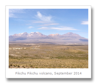
From the last stop, we could see Misti volcano, which is the sign that Arequipa is close, as it sits on one of the volcanoes slopes. It last blew in 1985 but still puffs away from the inner crater. A stratovolcano, Misti is often climbed by adventurers, and they even found six Incan mummies buried there in 1998 which had survived the earlier explosions somehow. Misti sits between two other mountains, one called Chachani, which is the highest at over 6000 meters, and Pikchu Pikchu volcano, which is really a string of peaks. But it is Misti with it’s symmetrical shape that gets most attention.


Our bus dropped us off at the hostel we had booked, annoyingly with little warning, and we almost got lost, with our bags just dumped outside the hostel with us nowhere near them. Luckily nothing was stolen, but I would definitely avoid the 4M bus, especially if traveling in the region for some time, as there are cheaper options which go the same route.

Built in the Chilli river valley in 1540 pretty much on top of a settlement of indigenous natives, Arequipa’s first main blocks around the plaza were given over to the Pizarro family and the church – a fact depressingly similar to all the other coastal cities in Peru.
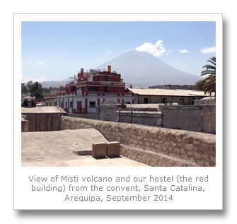
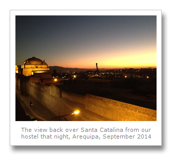
Our hostel, Hostel Reyna, was a bit crummy, even though it got rave reviews for it’s views across the city. We were in a room in the stratosphere on floor 4, and the showers were all totally hit and miss (mostly miss). The noise from the nearby clubs and bars were the worst thing though, so I’d advise against staying there. It is located right next to an old convent which is gleaming white, as is most of the historic part of the city center. This white stone is sillar, which is a volcanic stone from the extinct Chachani volcano formed in the Pleistocene era, and became very popular after the earthquake of 1687. Arequipa is known as the white city because of this.
We checked out the main plaza on our first day, after a huge debacle with our room key. The plaza was very pretty, one of the best we had seen in South America. Our first stop though, was some Jesuit cloisters off the side of the plaza. These were now a shopping arcade, but looked amazing.


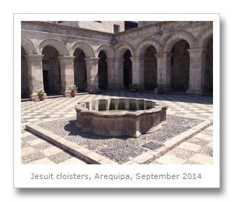
It was to Peru the Jesuits had first arrived in 1568, and Lima was their central headquarters. From there they implemented an indoctrination program of all Spanish and creole children, to establish a leadership class with Jesuit values. All Jesuit missions we had visited in Argentina, Bolivia or Paraguay were directly influenced by this wave of religion located in Peru. It was in 1573 when the Jesuits first arrived in Arequipa, from Cusco, and they were already building church and school right next to the main plaza as early as 1590. This school focused on teaching indigenous languages to the Jesuit elite, including Quechuan and Aymaran, to aid further indoctrination and conversion. Due to an earthquake or two, the building as we saw it, actually dated back to the 17th Century, although much modern restoration work had made it look as good as it did when we visited.
As in other Jesuit buildings we had visited, this one blended the Spanish Catholic symbolism with indigenous imagery, including using the Hapsburg eagle, and the Kantu, a flower that symbolizes Incan royalty.
Our next trip was to head over to the University Archaeology Museum which has zero information in English. We deciphered some information from Spanish, and worked out that most of the objects were from Southern Peru rather than just the Arequipa area. Some objects where found in local caves however, particularly some cave paintings, thought to be 8000 to 6000 years old. On display were some of the wooden objects and stone arrowheads found from the time, and some mummies we think were found on the nearby volcanoes, from a more recent Incan past.

After this small museum, we wandered down to the Andean Sanctuary Museum, so-called as it is home to a mummy called ‘Juanita’. This mummy was an Incan sacrifice found on the nearby Ampato volcano in 1995. A young girl was murdered, apparently as part of a ritual sacrifice according to experts, and was buried on the volcano and left to freeze for centuries. We would come back to this museum, although it was similar to the MAAM museum we visited in Argentina that held three similar high altitude mummies.
We decided to attach onto a walking tour next which met on the plaza. We first visited a temporary exhibit about the topography of Arequipa in the Sanctuary Museum. After that we heard some tidbits about the cathedral, the Jesuit church (Iglesia de la Compania) attached to the cloisters we had seen already, and we also visited a typical Arequipan house (now a business) to view the Moorish-inspired Spanish architecture.


We finished up back near our own hostel, at a weaving center, where you can learn more about llama, alpaca and vicuna. One thing we found out was that a shirt made from vicuna wool can fetch up to $1000US. We had heard some of the animals spat at the tourists here, but unfortunately that did not happen. A free pisco sour later, and we were free to go back to our hostel and relax.
The next day we headed over to the UNESCO Monasterio de Santa Catalina, which was right next to our hostel. This convent was founded by the Dominicans even before the Jesuit school and church way back in 1579. The nuns renounced all worldly items (to the church of course) and never saw their families again – and people still join even today, although now there are only a handful of nuns left.


We found one cell (nun’s room) that was lived in by Sister Ana de Los Angeles Monteguido who lived in the convent until she died there in 1686. She has a cult following since the Pope Jean Paul II beatified her for seemingly no particular reason. All of her crap was still in the cell as it (possibly) was.
One of the many buildings that were damaged in the 1958 and 1960 earthquakes, it has now been restored, and was a nice way to spend a few hours. The sillar buildings and pretty gardens were lovely to look at, and the many rooms which act as a museum to times past were interesting to wander through.
My favorite part was either the orange tree cloister, which smelled like citrus of course, or the view point on one of the rooftops which afforded views over the city and to the Misti volcano nearby.
The convent area is a healthy 5 acres big, so it takes a while to see it all, but it was pretty cool – definitely much more worth the UNESCO title than many crappy places we have seen elsewhere in South America. The convent is considered a city within a city, and with its many cloisters, churches, kitchens, rooms, patios, gardens and more, I have to agree.
We also visited Casa del Tristan del Pozo which was another great example of the sillar architecture in the city. A heritage building from 1738, restoration has seen to it that the façade of the doors and windows are all originals, and the Spanish-Indigenous baroque styles have all been exquisitely maintained.
One last architectural visit we made that day was to the main cathedral in the main plaza. We had heard about a huge wooden carved Satan in the church, so we wanted to check that out, as well as the bell towers on the roof. The cathedral is as old as the town itself, with construction on it starting the same day the city was founded. It has been destroyed several times in the past, by fire or earthquake, including most recently in 2001.

The little museum the cathedral had was filled with the usual gold and silver ornaments, and some scary priests robes, but it was the bell tower with it’s really old and heavy bells that were the most interesting things. Well, that and the huge carving of Satan.


Francesca then headed into the Museo Santuarios Andinos, which was the museum holding the sacrificial mummy.
We jumped into a taxi and headed for the Yanahuara district of Arequipa. This area was up the hill slightly and so gave great views over the city and it’s neighboring mountains. This middle class area is based around it’s pretty plaza, and when we were there, a Peruvian band were shooting a music video from the iconic viewpoint with Misti volcano in the background.
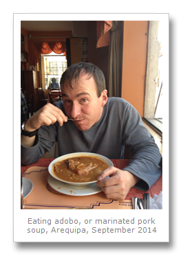
Hungry, we headed for a Picanteria and ate an Adobo. The former is the name for the traditional Arequipan restaurants serving local food, and the latter is a marinated immersion of meat into a spicy broth or soup. This tasted delicious, even if it was a little expensive, especially the onions and pork.
Yanahuara was nice, but a little quiet, so probably better to walk or get a bus there if you are a backpacker. Also there are many Picanterias all over the city apparently, so no need to go there just for that either.
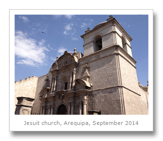
We headed back to the city, and on the way we got some more photos of the Jesuit church, and also tried a new thing – Arequipan Rocoto Relleno cupcakes. These were spicy meat-stuffed peppers, but unfortunately they did not impress that much, because they were too dry.


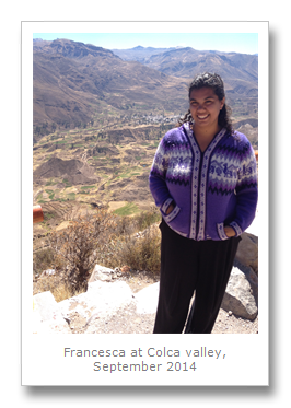
The next day, Sunday the 14th September, we were picked up from our hostel by Illary Tours, and after a bit of nightmare where we lost Francesca for half hour, we were finally on our way to the tour we had booked to Colca Canyon. Reaching a depth of 4160 meters, this canyon is one of the deepest in the world. We had negotiated with a travel agency on the plaza for a bit of a discount, but essentially they all do the same tours.
We set off back the way we had come from Puno a few days before, heading into the reserve where we could see the familiar sites of the surrounding three main volcanoes around Arequipa. We also made a short stop at a viewpoint for a mountain called Nevado Mismi, which is the source of the Amazon river. We then stopped for some tea and saw some of the more active and smoking volcanoes in the reserve, and then we headed North towards the town of Chivay, which stands in the Colca Valley, East of the canyon itself.


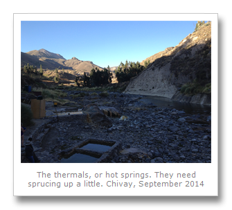
In Chivay we checked into our hotels and avoided the over-priced restaurant the tour agent took us to. The hotel was not too bad for such a cheap tour, but there was not much to do in Chivay itself. We met up with the tour again at the plaza, where there were lots of touristy stuff going on. Stalls full of tat, women with poor domesticated falcons on tethers and children dancing around with blaring music. We piled in the van again, and went to some natural hot springs on the edge of town. It looked like there were several different ones for the numerous other tour companies to go to.
Our hot springs, La Calera, were a collection of three pools that progressively increased in temperature. We got changed and relaxed in the pools that were next to the Rio Colca. It was nice to sit in the waters and relax together after so much driving that day, and afterwards we headed back to our hotel for a rest.

After dark that night we went and got some food from a local pizza restaurant where they tried to stiff us on the bill (a common tactic in Peru). After the ensuing argument in which we did not back down, we walked across the small town to the local observatory. Connected to a hotel chain, it is nothing more than a small observatory, but with a pretty good lightshow. The lady told us all about the Southern sky, including where some of the Incan constellations were. We got to see different stars and clusters of stars including the seven sisters and our favorite – Scorpio!

The next day, after an uninspiring breakfast, we were picked up by the guide and continued West into the Colca valley and onwards to the start of the Colca Canyon. Tours do not go into the canyon and they tell you there is no road to get there, but there is. Tours actually stop at what is called Cruz de la Condor, or Condor’s Cross, which is a viewpoint over the canyon for the huge vulture-like birds synonymous with the Andes. We saw a few condors on the way there, which the guide failed to point out or acknowledge, but when we got there, there were a few young condors that turned up, soaring a few meters from us and about two hundred other tourists all taking pictures. Talk about touristic! After this we did hear how the locals would leave dead carcasses at the bottom of the canyon here to attract the condors for the tourists, so that kind of ruined it a little. The canyon was only about 400 meters deep at this point, and you could not see the bottom from the viewpoint. The only way to really get good views of the canyon is to go there yourself and do some trekking – either by local bus or car rental.


On our way back after an hour or so at the viewpoint, we stopped at a few of the towns along the valley. Not much to see, but overall, the trip would be worth it if you had very little time in Arequipa, and had nothing better to do, but we would not recommend Illary Tours as their guide is such a tool.
The next day we went to the Convento de la Recoleta which was a 17th Century colonial church. With its large museum consisting of four cloisters, twelve showrooms and a large library housing some of the oldest books found in South America, the church was definitely worth a quick trip. Highlights were the amazon section, where various artifacts that the original missionaries bought back with them, including lots of scary taxidermy were presented, and the main library with its books.

The Recoleta library was built in 1661 and was comprised mostly of donated collections that had been brought overseas from Europe.


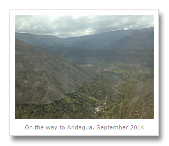
On the 17th September we decided to pick up a car from AVIS and set off West out of Arequipa. As the Colca canyon tour had not been very satisfying, we got ourselves a Toyota RAV4 and headed towards the other end of it, towards a town called Andagua. Road works and diversions made for a stressful time getting out of the city, not to mention my first manual gearbox since I was about 20. We eventually got out of the city and drove along the Southern Pan American Highway with all of the terribly aggressive Peruvian drivers. After a few hours traffic began to thin out a bit, and we found ourselves pleasantly chugging along past much better scenery than we found in Colca canyon.


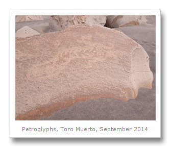
Our first stop was in the town of Corire. This town itself was pretty unremarkable, but the little privately owned land called Toro Muerto was not. The name, meaning dead bull, was given to the area because of an incident where a number of cattle died there due to thirst. When you go there it is easy to see why.

Entrance is paid at a blue control house where the guy gives you a map and directions, then you head up by a sandy road to the site. A huge field of sand and rocks leads up into the mountains, and so we parked our car and started the fairly difficult walk up.
On reaching the first summit we saw the field just kept going and going, and so we kept walking. This field is full of petroglyphs, or rock carvings, from the Wari culture era. As with the other petroglyphs we have seen, no-one really knows what their purpose was, or if there even was one. The most likely explanation according to experts is that they signify a signpost of some sort. I was not convinced – maybe they are just art, or maybe a way to teach kids language with the pictures. There were mostly llama carvings, but also a large variety of other things, including puma, lizards, snakes / rivers and many more.


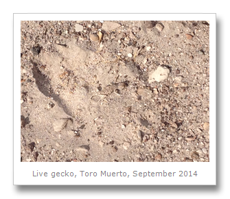
We did see actual snake tracks in the sand, and when we got to the back of the field there was a giant and pristine sand dune heading down into a sort of valley. We had gone so far that we no longer saw the footprints of other visitors that we had seen at the start of the field. We walked around to the top of a hill where saw a cave in one of the mountains. It was getting late when we spotted some large puma tracks on the hilltop – even though the warden specifically had told us that they do not have puma there – that is how difficult they are to spot! The guy worked there for years and never saw them, even though we clearly saw the tracks.
Francesca’s favorite carvings were that of some dancers which looked really strange. There were also volcanic bombs littered across the field from the surrounding valleys. It was possible that a volcanic explosion had torn apart some caves where these carvings used to be, but this is unlikely, as the rocks are not burned in any way, and show no signs of melting. However, inexplicably, there are some rocks where the carvings show huge ten ton rocks have been split apart by some unknown force. Very odd.


We headed back to the car, noticing a few other visitors had arrived – they had better watch out for the puma! We drove to the neighboring town of Aploa and stayed in a hotel o the plaza called Willy’s.
Aploa was OK, but we went to bed early as we had a lot of driving to do the next day, and we had a few encounters with extremely drunk men who we were pretty weary of. I’m glad Francesca did not go on her own!
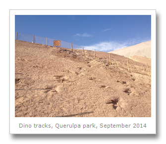
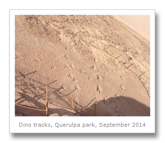
The next day we drove about ten minutes back down the road we had come back towards Arequipa, and we visited a little private park called Jurasico de Querulpa park. Another walk up a hill inside the tiny park led to an exposed piece of rock that was millions of years old. Fairly large bipedal dinosaur tracks were all over the rock. It looked like the rock had probably been mined and now the footprints were exposed for all to see, much like in Sucre in Bolivia (only much smaller). The footprints were left when South America was part of Gondwana, and there were huge lakes all over this area before the Andes began pushing up due to tectonic activity. The theropods have been found to be up to 12 meters high, just from their footprints!
After this park (donation only), we drove back through Alpao, and started to head North towards our final destination that day, the valley of the volcanoes. We drove up some crazy roads, single track with dizzying drops on one side, and rock fall-prone cliffs the other side. The road snaked up extremely high and steep mountain and volcano slopes, sometimes going up over 1000 meters to 5000 meters above sea level. It was tough trying to drive at that altitude, especially with the roads in such a bad state of affairs. We only saw a handful of road signs, and often no people for hours, so it was pretty easy to get lost without a map.


Eventually, after getting lost quite late in the afternoon on a mountain high pass when it started snowing, we made it down to the town of Andagua. Andagua is a bit like a forgotten Old West town. We found only three hostels in the town, all three of which were closed. There were no restaurants either, only little shops which old Peruvian women ran, pretty much from their houses. We finally got someone to open up a hostel and we got some food together.
Unfortunately that is when I pranged the car door, after all the driving across dangerous roads with huge steep drops and rocks everywhere, and I prang it on the side of the hostel with plenty of room whilst trying to park. Doh! That eventually cost us another $100.
The next day, we grabbed some breakfast, but we got a bit stressed out about the car door. However, we still managed to drive around the valley a little, and even found an old pre-Wari ruin which had been built on the side of a volcano, on some volcanic debris. Basically a load of thousand year old ruins built on and out of a volcanic lava field. Awesome!
We wandered through the volcanic flow, and then headed up to the viewpoint to look over the valley. Dozens of old and extinct cone volcanoes were scattered all over. We could see mining activity in the area, so maybe that explains the lack of tours to the region (that and the terrible roads).


The many different volcanoes, all with strange Quechuan names such as Puka Mawras (red), Yana Mawras (black) and T’iksu (meaning slanted), and it was nice to finally see the place after not having much information online or in Arequipa.


We finally headed off, as we had to get back to Arequipa that day. There was no direct route through the Colca canyon, and so we had to drive around the complete loop through the mining town of Orcopampa to get back to town. Orcopampa had some sorely needed food and petrol which we purchased, but if we thought that the road to Andagua was bad, it was actually much worse through the mountains. The road was barely drivable in our 4X2, so it would be a nightmare in a normal car.


We actually got back to Arequipa after some two or three hours of nighttime driving. We had to park it in the car park of a hotel in a really tight space, which was a bit hairy after the prang the previous night. However we got it done, and then handed the car back in the next day.
Arequipa was a nicer looking city than most, with the best plaza we had seen since Sucre in Bolivia. The activities were a little limited though, so if coming to Peru for a limited time only, I would have to advise other places to go instead.
No comments:
Post a Comment