Malargue Part 2: Daytrip to the volcanoes! While Colin stayed back to get some work done, I headed out on a full daytrip to an area called Reserva La Payunia driving more than 400 kilometers in one day to a place with one of the highest concentration of volcanoes in the world. We were supposed to leave that evening on a bus to Neuquén, as we had arrangements with a couchsurfer for the following day, so it was quite important I make it back from the daytrip on time. I let them know the situation, we’ll see how it goes!
The trip started off with a drive along the famously scenic Route 40, the longest road in Argentina, which goes all the way from Jujuy in the North to Rio Gallegos in the South. We drove by the Malargue River viewing lots of 400 million-year-old red rock from when the world’s land was Pangea. As we drove through the flat pampas, we noticed tall trees, such as poplar trees, in certain areas. Those trees were not native to the area, and were instead planted for protection from the wind for people’s farms. There were plenty of farm – and wild – animals around as well. We passed a family of 4 donkeys with 2 babies and stopped in an estancia with plenty more animals! After a breakfast of toast and jam, our guide took us around the back to see baby goats! They were cute to watch but they cried just like baby humans (my ears!) - still got a photo with one!


The group continued driving with our guide pointing out interesting animals, such as roaming families of guanaco. Unseen but present were foxes and puma, the guanaco’s predator. There were 115 different species of bird in the area, and we could see the evidence. One example was the white bits of the mountain where condors were nesting. I managed to spot two groups of choique, or lesser rhea, smaller than a typical rhea but otherwise looks the same. There were cool birds in the trees as well! Our guide pointed out the huge nest of a agilucho comun bird, or red-backed hawk, we assumed was empty, and I snapped a few quick photos. I looked at the photos closely once we passed the nest – I could see the bird poking its head curiously out of the nest!
The highlight of our animal spotting was when the car parked suddenly and our guide jumped out. He returned holding a hairy armadillo! It was wiggling all over, and we could see its hair, scales, and soft underbelly protected by the hard armor on its back. After we got a good look, the guide placed the armadillo back on the ground and we watched it dash away, running on its little legs at lightning speed.


As we drove through the pampas I spotted a huge antenna 35 meters in diameter in the desert. This antenna is known as ‘Deep Space Antenna 3’ and it is part of the ‘Deep Space Project’ Argentina runs in partnership with European space agencies. I found out online that this antenna is helping to provide support for various space missions such as Venus Express, Mars Express, and Herschel and Planck. I couldn’t get more than a blurry blob as a photo, so here is a close-up one from their website.

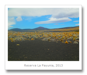
Off of Route 40 now and heading down dirt roads (thankful that we had our 4x4 – we needed it!) our group headed into an expansive flat pampas, which became more and more covered in black volcanic ash and rock the further we drove, the ash giving this area the name the ‘Black Pampas.’ This area is home to more than 1,800 volcanic cones, and with each eruption the ash covered the ground making it difficult for many plants, and impossible for any trees, to grow. There were green and yellow grasses and cacti bringing color in places, as well as smatterings of a red color which was oxidized iron. This made for stunning photos with the blue sky. One of the plants we encountered was a cacti our guide told us was called the ‘mother-in-law’s cushion,’ however, I looked up that species of cacti and the information claims it is endemic to east-central Mexico and critically endangered. It is supposed to grow on volcanic areas however, though I’m uncertain this is one because it looks nothing like the photos of other ‘mother-in-law’s cushions’ I found online. Any plant lovers out there who can help me figure it out?


As we drove through the volcanic fields, we saw dozens of oil drilling rigs spread throughout the landscape, dotting the area we found so beautiful and environmentally important. A few signs of protest were nailed up on wooden posts, calling out the Argentine company YPF for their actions. Apparently drilling is allowed despite the area’s designation as a reserve because the oil drilling started in 1982, a few years before the formerly private land was given to the government in order to make the area into a reserve. I’m curious why La Payunia has not been designated as a National Park as well, instead of just a Provincial Reserve, but I haven’t been able to find an answer. I do know that UNESCO is considering making La Payunia a World Heritage Site - hopefully this designation will force YPF to scale back or stop their exploitation of the area.


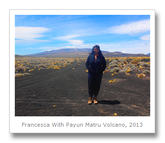
The highlight of the volcanic park was seeing two stunning volcanoes: The Payun Liso Volcano and the Payun Matru Volcano.
We could see the Payun Liso Volcano in the distance and one of our goals for the day was to drive much closer to it for some better photos. This volcano measures 3,360 meters tall and last erupted just 5000 years ago. Because of this recent eruption the area around the volcano is very black with few plants at all.

We didn’t try to get closer to the Payun Matru Volcano – because of its long size the impressive view was from far back. The Payun Matru Volcano is a massive 3,700 meter high and 300,000 year old shield volcano. The Wiki on shield volcanoes tells us the following: “A shield volcano is a type of volcano usually built almost entirely of fluid lava flows. They are named for their large size and low profile, resembling a warrior’s shield lying on the ground.” (Shield Volcano Wiki) The Payun Matru Volcano contains more than 300 eruptive centers and was formed by the Nazca tectonic plate (the plate of the Pacific ocean) being pushed under the South American tectonic plate. Our guide explained that this volcano is similar to ones found in Hawaii, except massive. When this volcano collapsed 168,000 years ago (collapsing is usually due to an eruption which leaves the magma chamber of the volcano empty and unable to support the volcanic cone’s weight) it left a caldera or cauldron measuring a whopping 8 x 10 kilometers. This volcano is known for producing large volcanic crystals and impressively contains the longest lava river in the world measuring about 180 kilometers.
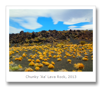
Lava is formed when the temperature in the center of the volcanoes is so hot (in this case 6000 degrees Celsius) that its rocks turn into liquid. There are two types of lava, given Hawaiian names: aa and pahoehoe. Aa lava is formed when there is quick flowing lava, often from an ‘Explosive’ eruption, which tears off chunks of surface crust. These chunks become coated in liquid lava and the result, when cooled, looks like dark, sometimes reddish, cubes of rock. Pahoehoe lava is formed when there is slow flowing lava, often from a ‘Hawaiian’ eruption. This slow lava does more ‘oozing’ out down steady slopes and thus ends up with a much smoother, sometimes twisted looking lava. While these two types of lava are the most distinctive, there are other shapes of lava which are considered to be a combination of the aa and pahoehoe types.


In addition to explaining the different types of lava, our guide showed us multiple ‘bombs,’ which is the term for any airborne projectile from a volcano. We saw some bombs that were more rounded than others which meant they were thrown further by the volcano – more time in the air makes for a more circular bomb. One of the bombs we saw had burst apart because water had gotten inside it at some point. The water expanded as it froze to ice which broke the bomb apart.


We next drove through the black pampas in order to get really close to the Payun Liso Volcano, stopping for plenty of photo ops along the way.


Once we reached the best photo spot, the results were spectacular.


Stopping for a lunch of sandwiches and fruit gave us time to see Payun Liso Volcano close-up and observe even more of the fauna in the reserve. I saw a new little rodent which I thought was a squirrel when I first spotted it. However this rodent didn’t have a tail, and when I asked the guide I learned it was a chinchilla rat, a member of the chinchilla family.
After lunch we climbed on the volcanic rocks. Under these rocks was a lava river, and above them we found a family of huge rodents named plains viscachas. Plains viscachas look like large rabbits (up to 9 kilograms) and they are known for their female-based societies and complex family burrows.


Driving along again we watched as a group of 6 big rhea went dashing by us, running up the volcano. I could almost imagine they were dinosaurs living in a world of their own.
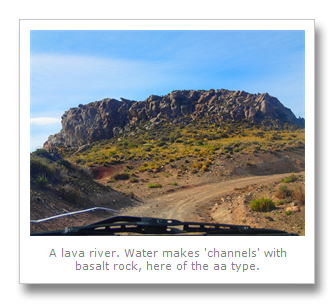
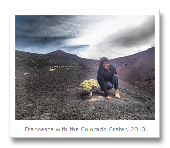
Soon we got to the Santa Maria Volcano its Colorado Volcano crater. Here we stopped to trek to the crater in order to observe it close-up. From the crater I could see a 17-kilometer long ‘Half Moon’ basalt field which was basically a curved path where the lava river flowed out during the eruption of the Santa Maria Volcano. It was quite surreal to know that at one point bright red hot lava was flowing down the path just below where you are standing…
At the very end of the trip we stopped at a rickety footbridge with quickly churning brown water flowing underneath it. We took a quick walk around it and I got some eerie-looking photos.


While we were driving back to Malargue I started to get a bit worried. The time for our bus to depart to the next city was coming up, and we didn’t seem to be close yet! I asked my driver and he called the hostel where Colin was staying, asking if Colin could meet us at the bus station so we could drive straight there – it was probably the only way we would make the departure. When my tour group arrived at the bus station I was grateful to see the bus still parked in the lot. It hadn’t left yet. I grabbed my day bag and headed to find Colin.
While he was glad to see me, he said the bus outside actually wasn’t our bus, ours had just left a few minutes before despite Colin asking the driver to wait a few minutes for me. We spoke with the bus company attendant and he tried to radio the bus to turn around with no luck. Thankfully two more people showed up looking for the same bus as us. Now there were four of us! The bus attendant tried to radio again, but quickly decided it wasn’t wise to waste more time. He told all of us he would take us with him in his car.
The four of us piled in, with our bags, and drove off speeding down the highway. Ten minutes later we saw the bus and drove ahead of it. The bus attendant leaned on the horn, waving at the bus driver to pull over so furiously that I imaging him pulling out a rope and lassoing the bus! The bus driver looked shocked – he didn’t want to turn the bus around, but since we were pulled up beside him, nearly cutting him off, he was convinced to pull over. The passengers peered out of their windows, wondering why they were stopped on the side of the road. The four of us thanked the bus attendant for going way beyond the call of duty and got ourselves and our bags on the bus laughing – what an adventure!
We were off to our next destination, ready to see some dinosaurs. Colin will tell you all about that.
Francesca
No comments:
Post a Comment