To get down to Ushuaia, the Southernmost city in Argentina, Colin and I had to take two bus trips which was a 2 day journey. Our first bus left Puerto Madryn in the morning, and we didn’t get into Ushuaia until the next day in the evening. Such a long journey! The journey was made even longer because in order to get to Argentina’s part of Patagonia, you have to travel through the Chilean part. And go through immigration. They don’t make it too easy! But that’s how far you have to travel to reach the ‘end of the world.’ The highlight of this journey was crossing the Magellan Straight by ferry.


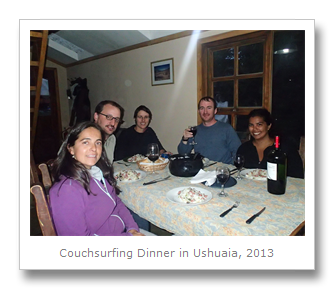
By the time we arrived in the city we were exhausted. Thankfully our host Mariano was there to meet us, and along with a couple other guests, we made our way back to his place for a lovely dinner together. When we woke up the next morning it was snowing like crazy! We knew we wanted to relax then head into town but we didn’t expect a snowy summer in Argentina – but it IS Ushuaia! Colin and I gathered our things and decided to learn a bit about the city that was now covering us in little crystal snowflakes.

First we checked out a couple of museums. There were plenty of museums in the city we were interested in, but we had to pick and chose the ones we actually attended carefully. At 80 or 90 pesos per person (and we were no longer on the Blue Dollar rate at 9 pesos to the dollar but 6 pesos to the dollar) these museums were really expensive to enter. We had done our research and knew learning about the indigenous Yaghan people, also known as the Yamana people was a must – so to the Yamana museum we went! Tons of models and dioramas, so get ready.
The story begins 20,000 years ago when the Beagle Channel was a huge glacier, and all the hills and mountains around Ushuaia were under ice. Over the next 4,000 years, the glaciers continued to advance crushing rock in its path. 14,000 years ago people came through the land bridge in the extreme north of Asia to the Americas and started populating and working their way down the landmasses.
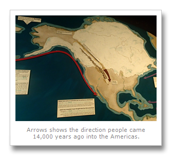

Then the global temperatures began to rise and the Beagle glacier started to melt away. Between 10,000 and 8,000 years ago this increase of global temperature led to an increase in glacial waters which resulted in the Beagle channel becoming a fresh water lake and the Magellan Straight land bridge becoming covered in water. Both areas were eventually filled in by the sea. Initially there was a land bridge where the Magellan Straight now is, which allowed animals and people to cross 11,000 years ago. It was during this period that the first people came to Tierra del Fuego.
Four different groups of indigenous people were living in the Tierra del Fuego region when the Spanish arrived. Two of these groups had stopped in the Tierra del Fuego region- the Ona (Selknam) and the Haus, a branch of the Ona and the first to arrive in Tierra del Fuego.

Two other groups of people traveled even further south. By 7,000 years ago, these first people had finally made their way to the Beagle Channel area. They were the ancestors of the Alacalufe and of the Yaghan, the main focus of the museum. These two tribes had similar ways but spoke different languages. I’ll describe the Yaghan primarily but specify if something was done significantly differently by the Alacalufe.


First of all, take a look at the map above. It has been estimated that when the Spanish arrived the 4 different groups numbered approximately 3,000 people each – 12,000 indigenous people total for the entire region. Their land was quickly gobbled up by the Spanish for colonies and sheep farming, and their lifestyle decimated by sheep owners, European seal and whale hunters, and ‘helpful’ missionaries. While it is said that their immune systems are to blame for not being ‘used’ to European diseases, it seems from books I’ve read (including A Brief History of the Land of Magellan by Mateo Martinic and The Indians of the Fueguino Archipelago by Antonio Coiazzi) that the sheep farmers as more at fault. The farmers removed the indigenous food sources by taking over their land, and moreover, the farmer’s militias hunted and killed the indigenous people, bringing back their ears for a bounty. These acts massively quickened the speed of their population decline.
There is only 1 full-blooded Yaghan left in the entire world, Cristina Calderon, who lives on Navarino Island south of Ushuaia in Chile. In an attempt to preserve her culture and ancestor’s history, she published a book of Yaghan stories in 2005 called “Hai Kur Mamashu Shis” or “I Want to Tell You a Story.”
The other fragments of information we have about these groups outside of Cristina’s knowledge came from the missionaries, but they were not able to stop the genocide of the indigenous peoples or their cultures. The idea of the indigenous as savage, almost ‘non-human’ was too engrained in the people of the times. One Yaghan man named Jemmy Button learned English in one of these missions, visited England, and ended up returning both to his native land and his native lifestyle wishing to have nothing to do with the so-called ‘civilized’ lifestyle of the Europeans, who thought him to be near animal. Charles Darwin said the following quote after meeting the Yaghans:
“[The Yaghans are] without exception the most curious and interesting spectacle I ever beheld: I could not have believed how wide was the difference between savage and civilized man: it is greater than between a wild and domesticated animal, in as much as in man there is a greater power of improvement." (Charles Darwin)
Backing up, the Yaghans ended up at the “end of the world” 7,000 years ago. These people lived in the area around the Beagle Channel and Cape Horn in makeshift homes and in canoes. They were nomadic, following mollusks, fish, sea lions, whales, penguins, and land animals in hunt. In the middle of their canoe they kept a constantly tended fire. These forever present fires are responsible for the regions name ‘Land of Fire’ or ‘Tierra del Fuego,’ as the Spanish saw fire everywhere upon arrival. While the men hunted marine animals with spears and harpoons, the women rowed and bailed out the canoe which was hastily made and often filled with water. Occasionally the women would need to swim, which they knew how to do but the men did not. When the woman needed to ‘dock’ their canoe, they laid it on a bed of kelp to protect the bottom.


While they did all these activities they remained almost completely naked, only covering their bodies in seal and whale grease. Colin and I wondered – with it so cold and often snowing or raining, how on earth could they go around naked? The museum answered that because the weather was so variable, if the Yaghan wore clothes they would often be wet clothes – and walking around in wet clothes is far less comfortable, and colder, than walking around naked covered in grease that dries quickly by the always present fire. Plus the Yaghan had developed some unique ways to fight the cold including keeping fires in their canoes and squatting often to conserve heat. Moreover Yaghan evolved with an average body temperature which is 1 degree higher than other humans.

Their religious beliefs consisted of a good god and a bad god. The bad god, named Curspi, brings the wind, rain, and snow as punishment. Because of this the rainbow is considered a bad omen from Curspi. While they believed bad spirits caused diseases, they also used a medicine man called a yecamush who ‘cured’ them in ways which were really just magic tricks. The yecamush would pretend to pull arrowheads or spear points from patient’s bodies, and he would claim the points had given the patient the disease they suffered from. The yecamush would often go into convulsions and put on a grand show for those involved during these sessions, and the Yaghan didn’t know he was tricking them. The good god sometimes gave the Yaghan a whale, stranded on the beach. Whoever found the whale would light a large bonfire to announce it and many canoes would show up with Yaghans seeking food for several weeks.
There was a small section on the Ona (or the Selk’nam) in the Yaghan museum, a group which was not familiar with the sea, accustomed to hunting and living on dry land. (Since this group was very similar to the Haush, most descriptions apply to both. I’ll describe the Ona primarily.) The Ona were known for being tall (more than 6 feet in height in some cases) and attractive with delicate features. They hunted guanaco, and used every part of the animal including the skins for their tents and their minimal clothes. (While the Haush people relied mainly on seals for this.) They maintained a ‘mature’ look at all times – never showing the childlike mood of joy when they received a gift immediately, preferring to appear stoic though they were actually a very happy people. Their creation story included Kenos, the creator god, Temaukel, the god of order, and other animal and weather-controlling gods, spirits, or shaman.

I’ll now describe an Ona practice, but the Haush and Yaghan had similar ceremonies as well. There was a secret ‘men’s club’ of sorts known as the Hain. Growing up all little girls and boys believed there were colorful spirits with different personalities, some which terrorized the group. However, while girls entered womanhood believing in evil spirits, the boys took a different route. During an initiation ceremony lasting several months, boys were tested by the ‘evil spirits’ who tried to scare them and make them complete tasks to show their bravery. At the end of the ceremony if they have passed, they learn that the spirits that scared them as a child were fake – they were in fact just the men in paint and bark masks. The men justify this act by claiming that it is necessary to scare the women in order to keep them submissive. They claim that in the past the women used to scare the men with the secret, running the same act against them. The men found out, defeated the woman and now use the ruse against them. In the defeat one woman escaped and became the moon and she is endlessly chased by her husband who became the sun.


While there is one full-blooded Yaghan left, there are no full-blooded Ona remaining. The last of these Ona, Angela Loij, died in 1974, and the tribe is now extinct – showing just how clearly, and unfortunately, how completely mass genocide took place in the Americas.
We learned an incredible amount at the museum, and we were really reminded just how easily human life is lost when there is a struggle between profit and survival. Back in the snow again, Colin and I headed to another museum, the End of the World Museum. The first section filled in a few gaps for us about the indigenous people and the missions which attempted to help and convert them – but unfortunately ended up just speeding their population decline due to how quickly the infections and disease spread between tribe members in an enclosed space. The second section was an exploration into the bird species in the region. There are 230 bird species in Tierra del Fuego! (And I swear, half of them were taxidermy and in that museum.) Compare this to the worldwide number of bird species at 9,800 and you realize how important the area is for conservation.

While the museum content was interesting, the back story on the building is actually even more interesting. The museum itself was built by the prisoners of Ushuaia – the building was originally the area’s first bank which, for 60 years, was the only back in Ushuaia.
While staying at our couch surfers’ place, I read a book on the history of Ushuaia which explained that the town was originally a penal colony which was created to help ‘secure’ Argentina’s claim on Patagonian land and to prevent other countries from colonizing the area. Prisoners, murderers, petty thieves, and even white-collar political criminals were sent from Buenos Aires to serve out their sentences building the town and its facilities – the bank, the trains, the roads, the government buildings – everything was built by prison labor! The weather was so cold and rough however that few prisoners were happy about making the trip to complete hard labor in the snow. A few of them had luck on their side though; it took so long to bring prisoners down to Ushuaia that some had served their full sentence on the boat on the way down (though in the cargo hold in darkness) and got to go straight back home!
As the town of Ushuaia grew, and as prisoners were released and stayed down in the area (they even advertised for wives for them in the paper in Buenos Aires to keep them down there) the prison was moved a few times away from the town. One of the moves had it in the Tierra del Fuego National Park – while we visited the park we saw ruins from the prison. The former prison is now a museum in the middle of town. We didn’t get to go inside (it was quite expensive and we learned plenty from the book already!) here is a photo of the outside.


Learning about the history of the prison really helped us put together the pieces when seeing their building accomplishments in town, as with the museum. But as the towns in Patagonia grew, there became increasing conflict with the indigenous in the area, who killed sheep on ‘private property’ a concept they didn’t understand.
Once it was determined by farmers that these indigenous in the area of Tierra del Fuego could be ignored or eliminated easily, there was a massive increase in explorer ships and immigrant settlers especially from the mid eighteenth century onwards – and increasing interest in the area from the outside world. Our next destination was a place where we could see how these past explorers charted their adventures. “De la Terra Australis a la Antartida” was a huge exhibit which took us from maps speculating about how many people were living in the world in the Classical era to the scientific exploration of Antarctica, the final frontier.
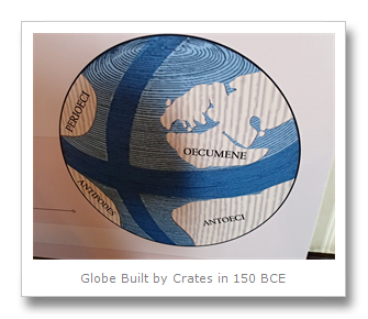
We learned that 600 years BCE the Greeks argued about the shape of the Earth, trying to determine if it was flat or spherical. Aristotle actually conceived the idea of a globe with two hemispheres separated by the equator, with climatic divisions. In 150 BCE, the head of the library of Pergamum, Crates of Mallus, built a globe using Aristotle’s hemisphere division, proposing the existence of four territorial masses within the equator divisions. They hypothesized that if the inhabited known world, known as ecumene, was living in one quadrant of the globe, it would be ‘unbalanced’ so they believed there must be additional undiscovered land on the Earth in the Southern hemisphere equal to that in the North. This land would eventually in the 15th-18th centuries be called the Terra Australis or literally the “South Land.”
Once these theories (four continents, five climatic regions) became widely accepted, the Roman writer Macrobio believed that the southern hemisphere was inhabited, despite its ‘extreme’ climate hypothesized. Church scholars drew maps showing these regions, believing that if there were any people in that area they were not saved because they did not know Christ. The German mathematician Johann Lambert came up with the Book of Flowers maps shown here in two separate views of the hemispheres. It is written in the book that the inhabitants of of the unknown area are an opposite race from human beings who experience a summer when the ‘civilized world’ is in winter, and winter during summer – and they cannot see the Northern stars.

Although hypothesizing about the state of the Earth was great for scholars, knowledge was only expanded with force once the prospect of profit was added. The importance of shipping routes with the Middle East and India led to exploration discovering the hypothesized land masses and their proposed inhabitants in the 1400’s and 1500’s. Creating new maps as new areas were discovered, and predicting additional land masses, inhabitants, and fantastical creatures became a growing trend. One map in 1508 by Francesco Roselli shows the Antarctic region hypothesized as below Africa. One of the first maps made showing a polar projection of the ocean’s southern hemisphere extending to 50 degrees south latitude was made in 1513 by Swiss humanist Heinrich Glareanus, yet it also contains misinformation such as an insular shaped new world and many imaginary islands around India.


Eventually the region was fully explored and the maps became more accurate, losing their extra land masses and fantastical creatures reduced to fossils and imagination. The predicted Terra Australis was found and Antarctica uncovered. There was an additional room which had many hanging globes around the room – they were the maps from old, turned into 3D globes! We really saw how wrong, but often right, people went in their understanding!

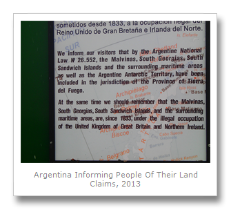
As we walked through town we spotted the Malvinas War Memorial. The Falklands, or the Malvinas as they are called in Argentina, is a sore spot between the English and Argentines. I read that the Queen of England served as a mediator between Argentina and Chile (as she had done in the past) for a conflict over some land in Patagonia. She assigned ownership to Chile and Argentina hasn’t been happy. Part of this unhappiness probably helped spark conflict over the Falklands. We walked in a circle around the plaza looking at some of the photos of various moments in the war.


We decided next to take a walk down to the port to book a cruise on the Beagle Channel for one of the following days. We saw signs up saying English boats were not allowed to dock in the Ushuaia port because of the Falklands/Malvinas conflict I mentioned earlier. Also, while we were walking we saw promotions for last minute cruises to Antarctica for $4000 USD per person for a 10 day trip. These cruises usually cost between $6000–$8000, so that is quite a savings! Unfortunately there were no special deals that included South Georgia and the Falklands, so we passed on the opportunity this time. But we will be back!


On the way back to our host’s place we stopped at a store which had all these figures in the back representing Ushuaia’s history – such as the prisoners working on the train. It started to snow like crazy by then, so I got some photos of the characters in the snow.


The 5th of December we did some admin work during the day and relaxed for a while. The weather wasn’t so great again (it was super windy!) so we only did a short walk later in the afternoon to get some photos of the whole city from a lookout point nearby. That evening we cooked up a delicious meal and dined with our host and some other guests over a couple bottles of wine.


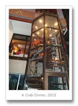
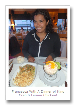
The next day was another admin day but we managed to get out in the evening for something I’d been looking forward to the whole trip: a King Crab dinner! Ushuaia is known for its King Crab, and we had seen many live ones swimming around in their tanks in the store windows. We ended up going to Tante Nina near the port. Since the King Crab wasn’t cheap, we opted to try an appetizer of King Crab cocktail along with some delicious lemon chicken for the main course. It was fantastic!


December 7th was set to be a really packed day. Colin and I caught the transfer in town to the southernmost national park in the world- Parque Nacional Tierra del Fuego. Our first stop was Bahia Ensenada where the infamous post office at the ‘end of the world’ is located. We both wrote some post cards to our Moms and mailed them out – though we haven’t heard if they’ve gotten anything yet and we fear they may have been lost at the tip of South America!
EDIT: The cards were received both in the UK and US. Yay!


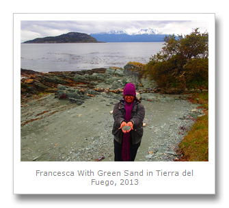
Parque Nacional Tierra del Fuego is named, as I explained before, for the many fires the Spanish saw when they first arrived in the region. Since indigenous Yamana lived all along the coast of the park (and kept ever-burning fires) the area looked like it was lit up everywhere. We started our journey with the ‘Costera Trail’ which was an 8 kilometer walk taking about 3 hours to complete between Bahia Ensenada (our starting point) and Bahia Lapataia. The walk took us along places with green sand, tons of bones and opened mollusk shells piled up – I could clearly seen the evidence of the Yamana natives even all these years later. There also were bunches of kelp growing all over the place which we learned the natives used to tie up their boats when they went fishing.
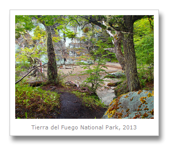
The scenery was beautiful with Lago Roca on one side and plenty of Antarctic beech, Lenga beech, and Coihue trees on the other. There were also plenty of peat bogs. Peat bogs are accumulations of dead plant material (mainly moss, reeds, and grasses) which have built up over centuries in the bottom of a damp valley, like the areas we were passing in the park. A combination of low temperatures and acidic water prevent the dead organic material in the valley from decomposing, and the compression of the layers and lack of oxygen forms the peat bog.
As we walked along the trail we came across a clearing which had a bunch of upland geese – white and black males, and some brown females. We heard one of the males whistling out, and I read online that when they do this the female geese typically respond with a low grunting noise in return. In some of the beech trees we saw a parasitic fungus growing in orange, soft balls. This fungus was called llao llao or Indian bread, because the indigenous of Tierra del Fuego used to eat it. You can apparently eat these raw but they are better cooked and have a doughy, slightly sweet taste. But we were a bit too wary to try them then…


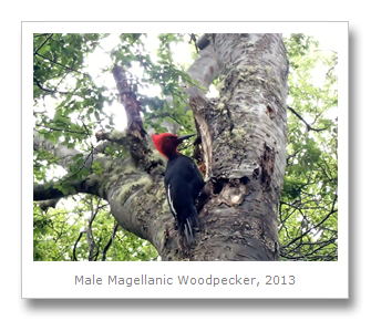
The highlight of the walk for us was a close encounter we had with a male Magellanic Woodpecker. This is the same bird we spotted a female version of in El Bolson (and earlier that day as well in the park!), although she had a less red body. This male was just stunning with its bright red head! It was making a really loud hammering noise as it searched for beetles in the tree’s bark. The highly territorial male and female build the nest and take care of the babies together, defending their nest from predators such as hawks. In Tierra del Fuego the numerous beavers have destroyed many of the trees providing plenty of dead trees for beetles and thus plenty of beetles for the woodpeckers. What an amazing creature – we managed to get a video!

The final part of our journey was to try and see a few beavers. Beavers are considered a plague in the area – we watched a video about them at one of the museums we went to which explained their history. Apparently the beavers (which are North American beavers) were brought by airplane from Canada because it was thought they could be bred and used for the fur trade in the region. Instead the beavers loved the area so much they got uncontrollable, spreading their destruction of the forest quickly. Beavers cut down trees in order to build dams which they live under. These dams protect the beaver’s homes, but they cause tons of problems for the forest if there are too many of them. Because there are no native predators for the beavers in the area, Tierra del Fuego is now filled with areas of muddy soil and fallen trees due to the beavers, and the damage is starting to negatively effect the other animals. There is a push now to eradicate the beavers, so its uncertain how much longer they’ve got!
As we walked towards the ‘Beaver Dam Trail’ we actually saw a cute little beaver swimming in the water of one of the lakes! It was carrying a branch in its mouth, bringing it back to the dam it was constructing. We watched as the beaver brought its branch home and maneuvered itself out of the water, dragging the branch along the shore with it. The beaver was quite far away (we got a good view through the binoculars) so we don’t have any photos but we did get photos of another, bigger dam we saw later while on the Beaver Dam Trail! We didn’t see any more beavers on this trail though, and Colin and I figured they had moved their home to the new location we spotted them working on near the lake.


Later in the day we caught the transfer back to Ushuaia – our cruise on the Beagle Channel with Patagonia Adventure Explorer ($380 Argentine pesos per person plus $10 pesos for the port fee) was the next morning!

The Beagle Channel (named for Darwin’s ship, the HMS Beagle) is a 240 kilometer long straight between Tierra del Fuego and a series of other, much smaller islands. We paid our port fee and boarded the boat, which took off almost immediately – giving us fantastic views of the island and the many huge ships in the port. Our guide called us into the boat after launching and pulled out a big map of the region. He asked if we knew the three natural water passages in the Southern hemisphere – they were the Beagle Channel, the Magellan Straight, and the Drake Passage.
Two of these we got to sail on, and one of them (the Drake Passage) we would cross later when journeying to Antarctica! In fact, most commercial shipping is done through the Drake Passage, so we’ll be in good company then! Our guide also explained that we would soon be coming to a lighthouse painted in red and white stripes for ships navigating the area. The stripes enable sailors to see the lighthouse better. I never realized that the stripes actually have specific meaning according to the number of stripes of their placement on the lighthouse. I couldn’t actually find confirmation of this online, but he said the red and white indicate how difficult the area is to navigate – red for danger and white for clear. Can anyone out there confirm or clarify?
Soon we came to some islands absolutely filled with animals – one with hundreds of black and white King cormorants which looked like penguins from far away. Another island had tons of fur seals laying on top of one another, looking as lazy as ever!


At one point during the cruise we stopped at an island and disembarked for a short walk around. Here we were shown Yamana middens, more clearly than I previously saw them in the Tierra del Fuego park because of their location in the grasses. The Yamana built their tents out of wooden poles and seal skins. They would have a permanent fire in the tents for warmth, and when they would eat they would use the area directly outside the circular tent as a garbage dump. Because of this, circular middens (circles of ‘trash’ consisting of mollusk shells, bones, stone tools, arrowheads, etc.) are found in a circular shape around any place where a tent was set up. I got to take a picture in one of them!
During our hike we also came across what looked like a large rock covered with bright green moss. It is actually a ‘bolax’ plant (which is really spongy yet firm in texture despite its rock hard-looking exterior) which is endemic to South America and prefers to grow in mounds in light sandy soil. Since they still need water, these plants have a compact growth and huge root system – they retain moisture very well. The plant has some medicinal properties, namely it is important for stabilizing activity of the red blood cell membrane.
On the way back to the city we saw a couple of Argentine and Chilean war ships roaming around, and the guide explained they were playing ‘war games’ and practicing with each other.


Next we headed into Chile – Colin takes over from here.
Francesca
No comments:
Post a Comment