We headed on a 7:00 AM bus back to the white city of Popayan on March 8th. Though it took us 5 hours to get back, we wanted to push on and make it to the city of San Agustin, another 5 hours or so in the opposite direction down a horrible rocky road that was bumpy and took forever. The region around San Agustin was the source of Columbia’s five major rivers – the Patia, Putumayo, Cauca, Caqueta, and the Magdalena. The area is also home to the mountains from where this water comes from such as the Paramo de las Papas, Paramo de Guanacas, the Coconucos, the Pan de Azucar, and the Nevado del Huila.
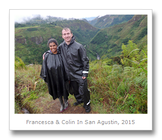
The scenery was fantastic – we were literally driving through cloud forest on either side, passing coffee and banana plantations as well – two of the most common export crops from the region. At one point just after our lunch stop, we came across a military base. The Columbian authorities made us all get out of the van and searched some of the passengers for drugs and weapons. They went into the van and looked through a couple of the bags as well. It was an annoying diversion as we were ready to get to San Agustin, and when we climbed back onto the van we faced another hour or so of bumpy roads. Once we arrived at the turnoff for San Agustin, Colin and I got out of the van and were transferred into an included taxi to make the final few kilometers uphill to the city. San Agustin, Columbia is a fantastically beautiful area!
Our taxi dropped us off in town (after trying to shuffle us to some of their own hostels) and I stopped with the bags to have a soda while Colin found and internet café and booked us in to a nice place for our last few days on our 2 year trip.

This nice placed ended up being Hostal Huaka-yo, a hotel (with affordable prices, however) owned by Cesar, a friendly Columbian we met on our final day at the hotel. Cesar lives in the United States with his American wife, and he was so cheery and helpful, a delight to be around – and his new hotel has the same atmosphere. We were uncertain about the hotel at first – the WIFI was out and we seemed a little out of town – but the internet (which actually came by radio and there had been a fire in the box, so no blame there) was working the very next morning, our room and bed were absolutely massive, the food was delicious, and the location just a short walk from the park was unbeatable. The hotel arranged all of the offered (and well-priced) tours for us as well, and we ended up seeing everything possible in San Agustin in the 3 days we had there without any trouble or hassles whatsoever. Very unique for South America, and much appreciated in our final days!


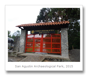
On the morning of March 9th, Colin and I had a couple of hours in the morning to explore the main San Agustin Archaeological park, which is the largest pre-Columbian collection of large burial mounds and stone funerary monuments of ancient chiefdom rulers. The 20 religious funeral mounds in the park sometimes included stone sarcophagi, stone corridors, stone columns, and more than 200 stone statues (most from the Regional Classic Period of 1 CE to 900 CE) of tomb guards, powerful warriors or shaman, supernatural beings, or anthropomorphic gods. They were created by the San Agustin society, a north Andean culture which occupied part of the upper Magdalena River between the 1st and 8th centuries CE. The fact that such an ancient society built these religious displays indicates a strong belief in the importance of religious (and likely political, as main political leaders were buried here) ceremonial activities. Overall, the entire San Agustin complex contains more than 600 stone statues guarding and displayed around 40 burial mounds.
We walked into the park and bought our tickets, then headed over to a map to see how big the park was. The park included Mesita A, Mesita B, Mesita C, La Estación, Alto de Lavapatas and Fuente de Lavapatas – which is a stone bed carved with religiously significant symbols, onto which a steady stream of water flows. Mesita A and C are the two oldest and the two largest of the sites.
The first place we visited was Mesita D, a small collection of funerary statues in an area which was used for ceremonial purposes.

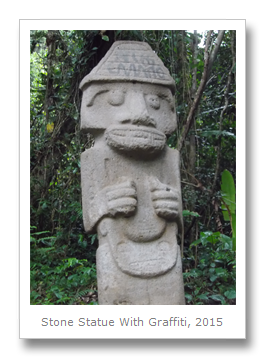
After a quick look at Mesita D we headed into the forest to see a collection of 39 larger statues known as the Bosque de la Estatuas. These various statues of deities, warriors, and shamans were placed in the forest for display purposes only, as they were originally recovered from looted and destroyed funeral mounds all around San Agustin.


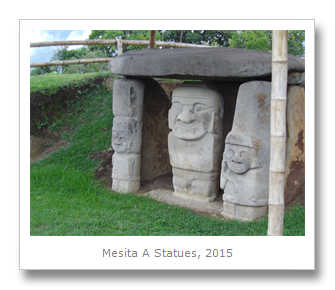
Colin and I left the forest of statues and headed towards one of the biggest sections of the part called Mesita A. ‘Mesita’ comes from the term ‘little table,’ so named because the stone slabs above many of the funeral mounds form a table-like structure over the buried body. This area used to be occupied by people 2000 years ago who built several dwellings on the land between 300 BCE and 1 CE. After this period, the area was converted into a burial site. In Mesita A, two funerary mounds were found which had been created during the Regional Classic Period of 300 CE to 800 CE. Three of the larger structures were tombs of elite individuals and some reached up to 4 meters in height and 10 meters in diameter. These tombs show evidence of secondary burial (bones placed in an urn after a primary earth burial, accompanied by ceramics and metal objects), which was common in pre-Hispanic societies and very similar to what was found at Tierradentro.


The next group, Mesita C, showed 15 different stone statues and forty-nine different tombs. Radiocarbon dating shows these tombs date from 1 CE to 900 CE, and many of the statues alongside the tombs are decorated with elaborate jewelry, including earrings, nose rings, along with musical instruments.


As we walked through the cloud forest, heading closer to the Fuente de Lavapatas (the Lavapatas fountain) we noticed a frog carved into a rock, with its head pointing towards the direction of the fountain. Some archeologists believe this may have been an ancient indication that the fountain was near – and of its direction.


We continued and reached the Fuente de Lavapatas, which was discovered in 1937 by Ernesto Gumis. This fountain has also been dated from the Regional Classical Period (1 CE to 900 CE) and contained multiple canals and pools, as well as carvings of humans, reptiles, and amphibians. There were numerous carvings of snakes, which symbolize water. Unfortunately, many of the carvings have suffered damage over the last couple of decades and archeologists are running an investigation into the source of the damage.


It was a long walk up to the next site from the fountain, which was called Alto de Lavapatas. This site had a great view of the surrounding nature, and has been used since 3300 BCE (radiocarbon dated from an ancient hearth) as a domestic area and burial ground – most crucially during the Lower Formative Period (1000 BCE to 1 CE) and the Recent Period (900CE to 1500 CE.) On the site eleven pit-like tombs made from stone slabs were found, which quite possibly could have been a children’s burial ground. One of the most interesting statues at this site is the restored piece called the “Double Self” (by archeologist Konrad Preuss) which has been said to be a standing warrior combining animal and human (male) features. The piece has been placed back where it was originally found.


At the end of the park was a small museum which showed us additional statues, along with photos of statues we had seen and how they were used as decoration for the town square, or as the foundation of people’s homes. The museum led us through a timeline of the site, starting with the Pre-Ceramic Period of 4000 BCE to 1000 BCE. Archeologist have only found evidence of fire, wild fruit consumption, and the basalt stone tools these nomadic individuals left behind. From the Formative Period of 1000 BCE until 1 CE, people began to establish permanent homes that were organized into small farming communities which cultivated maize near the main rivers. During this time there was not much stone carving, but building in wood taking place, and we have found their basic pottery in simple vertical-shaft tombs.
The Regional Classic Period of 1 CE to 900 CE period had an increase in both population, lithic art, and the society’s links with outsiders. People concentrated around the tombs and funerary centers which formed villages that some archeologists believe could serve as small political units led by high ranking people. This concentration of people led to political leaders gaining more power, and as a result some huge, complex religious stone monuments and reliefs were created.
Finally, the Recent Period of 900 CE to 1530 CE shows while the people occupied the same places and agricultural techniques seemed to have improved (terracing and the manioc crop were introduced), the building of large tombs and stone monuments slows down and eventually stops. Pottery styles change, and cultural seems to shift to a less complex social structure. This regression occurs between 1000 CE and 1350 CE, and is possibly due to an occupation of the region by the warrior Yalcones people or the Andakis people, the latter who came down from the Upper Caqueta river basin of the Amazon region. The descendants of these groups were conquered by the Spanish in the 17th century.


After the museum we headed back to the hotel for lunch. A short while later (as it began raining – but we were given ponchos!) we headed out on horses to see some more sites around town. The horses were really cute (though one of the poor things shoes fell off!) The first place he brought us to was called El Tablon – a group of four statues a few miles away from town. The carvings were very impressive, especially with their anthropomorphic features such as jaguar teeth.


Next we took the horses to the site of La Chaquira. We walked past coffee plantations, and headed down a bunch of stairs to see some beautiful waterfalls and a fantastic view into the gorge where the Rio Magdalena ran through. There were loads of birds flying all around the mountains in front of us, and the place just looked picture post-card perfect. We turned to where we had just walked to see images of divinities carved into the rock face of the mountain.


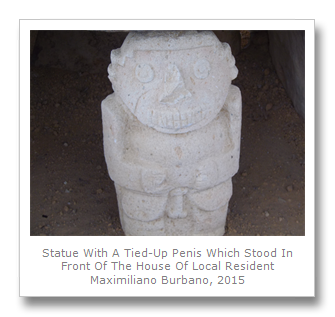
We took the horses next to the twin sites of El Purutal and La Pelota, which were quite near each other. El Purutal was some more brilliantly preserved, but now plain in color, stone statues. La Pelota dates from the 6th century, and was one of our favorites. The male and female statues at the site were very colorful, with their original pigment still showing. Our guide brought us over to a tree and showed us how it was one of the sources of natural pigment used by the statue’s creators. Unfortunately the statues were vandalized recently, having been painted over to brighten their colors.


On the 10th of March Colin and I were collected from our hotel for our jeep tour. The jeep tour was taking us to a few of the further away locations in the park, such as the Alto de los Idolos. Our first destination was the Estrecho del Magdalena. We took a few photos at the top, then climbed down the very slippery rocks to the bottom where we could feel the spray from the river.


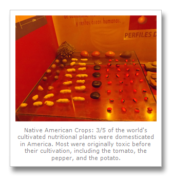
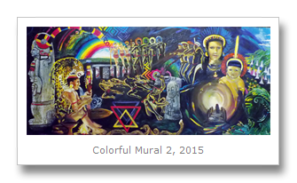
Our next jeep stop was a little museum called Obando. The site contained some 30 underground tombs, 8 of which were available to enter, and a display of the excavated pottery found in them. There were a few displays I enjoyed on local plants and crops. The museum also had some colorful murals on display showing some of the Spanish vs. Indigenous history.


After the museum we took the jeep uphill towards the next statue locations. Because it had been raining so heavily, the truck got completely stuck in the mud. Our driver didn’t know what he was doing and ended up taking OFF the 4 wheel drive before trying to gun it up the mountain. A few of the cars behind us managed to get themselves stuck in the mud as well and we ended up having to wait for more than two hours until they managed to get the car free. We got so bored we walked up the road and explored a local sugar cane factory. Once we got back in the car and started going again we were all starving, and gobbled up our food once we got to the lunch stop.

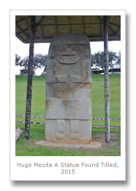
After lunch we headed inside the Alto De Los Idols and started quickly exploring the extensive site. Within the site were artificial platforms, drainage ditches, and funerary monuments. Some of the volcanic stone monuments on this site were more than 4 meters tall, and sat outside the stone tombs set up on the site. As we explored the site we came across statues in an area of Mesita A and an area of Mesita B. Both of these hills had tops flattened by the pre-Hispanic occupants, who connected the two resulting plateaus at the same level. The statues we came across in these areas were created between 1 CE and 900 CE, though the space has been occupied from 1000 BCE to 1530 CE. Again the funerary pieces found indicated the area was the political center of a chiefdom. The first statue we encountered was massive. The statue had been found buried 1/3 in the ground, guarding a tomb at its feet which was decorated with yellow, red, and black circles.


To the east we found Mesita B, which contained two graves. Both graves contained stone statues of crocodiles with teeth and clawed feet, and had remains of charcoal found in them.


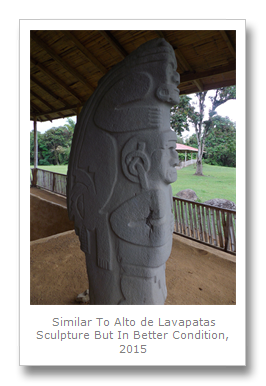
We jumped back into the van and half an hour later we arrived at the Alto de las Piedras, another funeral site, but one which had been severely damaged by looting. Here we found some stone graves which contained braided gold wires with polished green beads, along with 85 individual small gold beads and 10 square sheets of gold. There was another statue very similar to the one we saw at Alto De Lavapatas, but much better preserved. This statue was of a male human with jaguar teeth and a second human/animal figure on his back wearing a headdress on his head and back. The tomb where this statue was found was decorated in a geometric motif of black on a red background. Another statue we saw had a tomb with red and yellow paint, and one of the final statue was possibly that of a pregnant woman decorated with a headdress and necklace and black, yellow, and red painted geometric designs.


Since we were delayed quite a lot with the mud, our original plans of going to the Salto de Bordones waterfall were scrapped. We ended up going to a different, but equally beautiful, waterfall called the Salto del Mortiño on the way back into town. We got to take some fantastic photos of the parakeets flying into the waterfall, home for the evening and eager to get into their stone crevasse homes behind the protective water shield.

Once we were back in town, Colin and I booked our bus ticket to Bogota for the next morning. A taxi back and dinner waited for us – and one last night in San Agustin! And the countdown to leave Columbia…
Francesca
No comments:
Post a Comment