First impressions of Quito were not good. The traffic, pollution, and the up and downs of the roads at the high altitude all added up to an uncomfortable experience. Our hostel was located near the old town of the city, the colonial area. However, the transport system was terrible, in terms of a lack of information and overcrowding, anyway.
The views around Quito and the weather we had whilst we were there were all awesome though. The capital is surrounded by large mountains, including a volcano called Pichincha which even has a cable car running up to it.


On the 3rd February we headed down into the colonial part of town and booked onto a tour of the government palace. Quito itself was founded in 1534, but Carondelet palace was built in 1747, mostly from expensive European materials such as bohemian crystal in the chandeliers, to Italian wood in the furniture.


After the Battle of Pichincha in 1822 (featuring the Ecuadorian hero Sucre against the royalist Spanish forces) the palace became the headquarters of the Gran Colombia region, but after Bolivar’s dream ended, and Ecuador gained independence once again, the palace became the center of the country’s government.
A striking mosaic greeted us inside which was added in 1956. The mosaic tells the story of the discovery of the Amazon river, and how the Spanish fought their way along it, against female indigenous warriors (hence the name Amazon).
A colonial meeting room had long since been modernized, with wooden panels that hid projectors and screens mixed with historic chairs that bore the names of the presidential cabinet. Independence Square was right outside, and it looked very lovely in the morning sunshine – lots of people milling around amongst the palm trees and the central monument to those who fought for independence in 1830.


A brief tour of the banquet room and presidential chapel was next, and the lack of ostentatious power was evident as a conscious decision made by the current president who had run on a quasi-socialist platform as ‘one of the people’, and had opened up the palace to the public as a museum in 2007. True, there were gifts from foreign dignitaries on display, such as gold swords, posh dinnerware, and the like – but the signs all made it clear that Rafael Correa had already donated that stuff to the public already.


We did not buy the propaganda, of course, and it was topped off by a display of the humanitarian awards Correa had won – presumably not for his work in selling off the Amazon jungle’s National Parks, to the foreign and domestic oil industry.
After our tour, which was totally worth it, we wandered around Independence Square some more. Plaza Grande, formerly the Archbishop’s Palace was now a lovely suite of high-end tourist shops with some nice restaurants. We made our way to the Church of Mercy, a huge white-washed building that was badly damaged in the Quito earthquake of 1660. Ironically, Catholics who worship here now believe that the Lady of Mercy has saved Quito from numerous earthquakes over the years, the poor, sad, demented people. We saw some decent paintings and architecture at this church, but we did not get to enter the library with it’s books, because the entrance fee was prohibitive to two people who have no desire to give money to the Catholic Church.


We next found our way to the Metropolitan Cultural Center (after some wrong turns due to confusion from construction works). There were some informative plaques hanging at random points around the building, but other than that, there was literally nothing else to see! The building used to be many other things in it’s past lives including Atahualpa’s palace, a Jesuit school, and an army barracks.
We visited the House of Sucre after the cultural center. Sucre was the general of several battles including the battle of Ayacucho (present day Peru), and Pichincha (Quito). He lived in the house after the battles were fought and won, and the house was transferred to a different ownership, eventually leading it to become a hotel. The house was set-up as a typical colonial house even showing the walls made of wood and daub.

The architecture at the Jesuit Church was typically beautiful, with some great carvings in stone on the front. The church was much smaller than the San Franciscan Monastery, but was much more intricate. The monastery was in a pretty crappy neighborhood, and Francesca was not very well, but she after some food we both felt better and continued on.


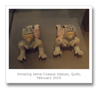
Our next stop was a pre-Colombian art museum, Alabado House. The artwork here was amazing, displayed as it was in a colonial house built in 1671. The exhibitions included the Valdivia, Chorrera, Tolita, Jama-Coaque and others cultures – the stonework was amazing considering that some of it was over 6000 years old!
Some of the explanations given by this museum were ridiculous – descriptions of labyrinthine designs on vases representing the universal current of energy that belonged on a Berkley campus. What we really know about these stone works and ceramics is that they are really old, and we can only guess at their function or purpose. It was a pleasure to see the paint still on the ceramics, and to see the anthropomorphic figures made of various stones from around the country.


The Tolita culture’s human ceramics were a little dark and disturbing, but they were more fascinating than the Valdivian toy-like so-called Venus statues that we had seen all over the region’s museums. The best pieces by far were the Jama-Coaque figurines – much more detailed and refined.


We hit the streets of Quito again until we came to an old colonial street called La Ronda which nowadays has loads of shops and small businesses along it. The Casa de las Artes was fairly disappointing, but there were some interesting paintings. We escaped the gallery after about 10 minutes and made our way down past the Santa Domingo plaza where a bunch of disgusting looking prostitutes were hanging around on the corner, even though it was midday. Gross.


We found the City Museum which was located next to an 18th Century archway called the Arco de la Reina which was used to provide shelter to those going to church. The museum was in an ancient building from 1563 and mostly had little model dioramas depicting events from Quito’s history, and typical colonial and post-colonial life. Back before the roads to the coast, and in particular, Guayaquil, were built, it used to take up to 15 days to reach Quito by mule – 3 days of which were needed to navigate volcano Chimborazo, whose summit is the furthest point on Earth from the center of the planet thanks to the bulge at the Equator.

Quito is laid out in a big long line along the valley floor, pretty much running North to South, for about 20 km or more. The valley now has a huge haze over it because the wind cannot get in there to blow the pollution away. Back in the 19th Century this was all just taking off, and farms at both ends of the valley provided the produce to supply the ever-growing town. Forests disappeared from the city by the 1850’s, and it was President Moreno who allowed the introduction of the Eucalyptus tree from Australia as a solution to the lack of lumber in the region – this in turn has been extremely harmful to the soil and indigenous animals of the Quito area.
Our last stop of the busy day was to see another museum called Casa Museo Maria Urrutia. Maria Urrutia was a noblewoman in the early 20th Century who was a multi-lingual philanthropist. She won the National Order of Merit and left her house to the people – now the house is set up as an example of colonialism. Almost every painting in the house was a Victor Mideros painting, who was rumored to be Urrutia’s lover. Every painting had her face in it, and vainly, she had hung them all over her house.

The house has a fruit alcohol distillery that made the mistella, which is a fortified wine. Also, in the kitchen they had it set up as it was, where they used to make fanesca, a rich pumpkin soup.
We did see the cathedral on the way back to our hotel. Built in the 16th Century, it was made the resting place of General Sucre 200 years later. An earthquake damaged the building in 1858 destroying the bell tower, and there was also a plaque that said that in 1875 President Moreno was shot and killed by the altar. Other descriptions of his death put the place of his assassination on the steps of the National Palace, so who knows?

The next day, the 4th February, was another packed day around Ecuador’s capital. We headed to the point in the old town where we had left off the previous day. Plaza del Teatro had some nice buildings from the 19th Century, but we had to take to wearing surgical masks to help with the pollution – something we had never had to resort to before. They did seem to help, so we will make sure they are on our list of things to bring for our next big trip.
We did not go into the theatre as it looked a little tedious inside, so we made our way to one of the biggest tourist attractions in Quito, the Basilica del Voto Nacional. We had been recommended to climb the clock tower of this neo-Gothic church for the views, but the cost was a bit prohibitive for us. Instead, we admired the outside – which was awesome! They had all manner of Ecuadorian animals as gargoyles adorning the church including Giant Tortoises, Giant Anteaters, Pumas and Caiman. Strangely, the street level alcoves all around the church were now locations for cheap local businesses, such as photocopy shops.


We found our way down to Parque La Alameda where the Quito Observatory is located. It is now a center for meteorology, but gained it’s inspiration from the First French Geodesic Mission back in 1736. It was President Moreno again who left his mark on Quito when he had the observatory built with the international cooperation from the Germans in 1864, making this the oldest post-colonial observatory in South America.


The observatory had several different themed rooms, from sea navigation, with it’s sextants and charts, to a room full of earthquake measuring devices and machines and an atomic clock.
We next walked down to the National Museum where they have a cultural center and exhibitions in the middle of a different park. When we visited there was an excellent exhibit called the Routes of the Sea, which was dedicated to early Pacific exploration and trade. Set in a large open-spaced room, the exhibits were all set out in the style of a large old ship and tracked the history of Spain and Portugal in the Pacific from the 15th Century onwards.
Attracted by the rewards and treasures of the Orient, exploration took place to reach the Spice Islands long after mathematicians and right-thinking people had realized the world was round. Even the ancient Greeks had worked that one out.


It was in 1492 that America was discovered by Columbus, landing as he did in the Bahamas archipelago. Things did not end well for him, as he was arrested and made to suffer years of litigation amid accusations of tyranny during his term as governor in the Caribbean of Hispaniola Island. It took only 21 years before Europeans found the Isthmus of Panama and then discovered the routes through to the Pacific Ocean – all from rumors garnered from the indigenous people.
One of the greatest things about the exhibit was it’s collection of the actual letters that recorded all of this historical activity, with copies on display and descriptions and explanations in English as well as Spanish.
Once the Spanish started settling the Caribbean, the Portuguese figured out what they were doing pretty quickly, and to end the resulting dispute, the Pope of the day drew a line across the Ocean dividing the area between the two nations. No-one had explored South America at the time, but the line effectively created the division which still exists today between Brazil and the rest of the continent.
It was Vasquez Nunez de Balboa who discovered the Pacific from South America after crossing the Isthmus of Panama in 1513. Even the currency of Panama is still named the Balboa after his achievement.
There were several more stories of various other ships that tried to get to the Spice Islands in Indonesia over the following centuries, with many failures and many deaths. Magellan was the first to discover the passage to the South which bears his name – but he was also one of the first to die when he was killed after trying to forcefully convert Pilipino natives on the island of Mactan. Eventually, of course, Spain did unlock the Pacific and it turned out to be a source of great wealth to the nation for many years to come.
There was an art museum next door, and so we made our way to it and took a look around. Some of the paintings were very good, including some great Surrealist pieces.


The Museum of Modern Art had a huge exhibit of Ecuadorian musical instruments from all over the country. Many of the instruments were made from the natural world, including Toucan beaks made into a musical necklace, a Tortoise shell drum and a Nine-banded Armadillo shell that would be scraped with some wood to produce some rhythmic noises.


The local university had a large exhibit on Yasuni National Park in the Amazon made up of photos taken of the wildlife and the local people. The photography highlighted the plight of the indigenous peoples in the jungle, and also the uncertain and dangerous future of the rainforest. It also showed us that we needed a much better camera.


There was a folklore ballet called Jacchigua that Francesca went to that night which was near the museums we had visited.
The show went through 10 different dances, starting with the ‘Traditions of Saraguro’ with dancers dressed like locals from the Province of Loja. In this dance many features were represented: the Saraguros, a “Dance of the Offerings,” humorous Wikis or monkeys, the force of the Ganil or Bull, and the traditional “Hat Dance” from the Commune of Las Lagunas. The second dance was called ‘The Deer Hunt.’ This dance was typically presented by the communities of Chimborazo in three phases: the “minga” to organize the hunt of the doe that is ready to mate, the hunt of the doe with the lasso, and the celebration of the capture of this beautiful animal at the patio of a Indian house. This dance was one of the better ones, as it involved people dressed in tiny deer costumes running around!
The third dance was called ‘Chagras’ and represented the traditional foods eaten by all Ecuadorians: corn, fava beans, different types of tubers, potatoes, and guinea pig. The fourth dance was called ‘Poem To Life’ and the choreography in this dance is dedicated to honor all the women in the world with dignity, as creators of life. The fifth dance was called ‘Sanjuanadas – Dance Of The Ribbons,’ and was a unique symmetrical dance that Indians and mestizos dance in honor to the sun and the earth, especially during the solstices and equinoxes.
The sixth and seventh dances were ones with religious undertones, called ‘Jesus The Prayer Dance.’ The seventh dance, ‘The Feast Of Corpus Christi’ was an Indian ritual that was celebrated for 21 days and 21 nights in honor of the sun, the earth, and the harvesting of the corn. The eighth dance ‘When The Rooster Sings,’ was also a dance of love, due to its amorous movements. The ninth dance, the ‘Dance of Peace’ showed a ‘we are the world’ style dance with different colors of the rainbow represented. Finally, there was the tenth dance or the ‘Feast of Saint Peter And Saint Paul,’ which was led by the Diablo Huma. During this dance the Aruchicos descended upon the plaza, dancing, stomping and yelling to the rhythm of ancient wind instruments called chinucas.
Many of the dancers wore Panama hats and other traditional Ecuadorian outfits – and Francesca reported back that some of the dances, especially the Diablo Huma character and dance, were very similar to some other folklore dances we had seen in Bolivia.


The next day we taxied around the city, first visiting the cable car that runs up the side of the Pichincha volcano. It went very slow to start with, then shot us up the mountain to great views of the surrounding cordillera. Cotapaxi was in the distance and we could just about see it through the clouds. Quito looked great from the top, even through the hazy smog, but we chose not to keep going to Pichincha itself, as it was very windy and cold along the trail.


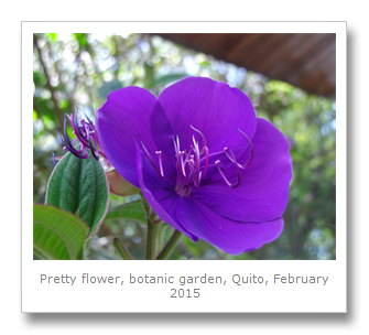
We came down and headed to the Botanic Gardens in the park. The gardens were arranged in different environmental sectors, with endemic and native Ecuadorian trees from different ecological regions planted throughout. We saw cloud forest trees, rainforest trees, and even dry forest trees. Hummingbirds zipped to and fro, including ones with very long tails, and the Orchids and Cacti were really nice to look at.
There was a huge collection of Orchids at the gardens, and even a separate greenhouse full of carnivorous plants – mostly with huge bulbous leaves that would be used to drown flies and process the resulting nutrients. These plants give off odors that flies are attracted to to lure them in, then they trap them in the pools of water, or even with sticky sap that they secrete.
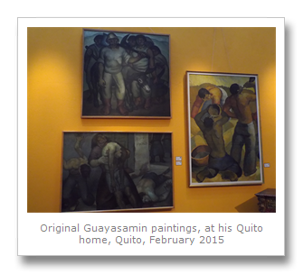
We stopped at the garden for lunch, and then made our way up into the mountains to a famous artist’s house – Museum of Guayasamin. Oswaldo Guayasamin was a master painter of Ecuador, and of all the artists we had encountered in South America, from writers to painters and sculptures and more, he was the one we admired the most. True, he seemed to have the same old tired Communist pretentions that many others had, but populism aside, Guayasamin seemed to have mastered several painting styles much better, and be more real than all the others put together.


Some of his work we liked better than others, and he had a penchant for collecting rare pre-Colombian art which did not seem particularly fair, responsible, or even legal. He died in 1999 though, and left his estate to the people, and so now you can tour his house and studio pretty much as it was, and even learn about his paintings techniques.
When he was 23 one of his friends died in front of him during a violent demonstration in Quito, and this event had obviously influenced him tremendously. But his work is not all doom and gloom, and often seemed inspiring and relevant to us.
His largest work was the Chapel of Man, located outside the museum. A huge underground vault with many different floors are covered in the artist’s paintings documenting man’s suffering and ambition. He helped architect the building and exhibited his works in it up until his death in 1999. It opened to the public three years later in 2002.


Our last stop of that day was the Amazon Museum which documented the lives of the various tribes in the Ecuadorian jungle, and the pre-Colombian peoples of the country. The museums was called Museo Abya-Yala and they did try to fleece us when we arrived, but it was worth a quick visit to see a whole toucan made into an indigenous hat and some sloth and human tzansa (shrunken) heads, even though we were not allowed to take photos. The best part about the museum was a collection of photographs taken by Judith Kimerline, 2011 Albertson Medal Winner and author of the book Amazon Crude, and Giovanna Tassi Cedime in the 1980’s and 1990’s. These photographs showed oil contamination in the Amazon, both inside of Cuyabeno Reserve and Yasuni National Park.

On the 6th February we took a bus out to the middle of the world monument which is on the Equator line itself. La Mitad de Mundo is a theme-park with numerous museums and a large 30 meter high monument which receives many tourists every day. The monument was built in 1979 to commemorate the Geodesic Mission that inspired the observatory. In 1736 a French mission from Paris led by Louis Godin, Pierre Bouger and Charles Marie de la Condamine came to Quito to measure an Ecuadorian meridian compared to a European one – which ended up proving that the Earth bulged in the middle, and was not a perfect globe, but oblate.


We were lucky enough to have been given another couple’s entrance bracelets when we went in and so we got into a few museums we shouldn’t have. The place was OK, but you will only need to go in on the cheapest ticket, and plan on spending an hour or two at most.
We took the bus to a nearby volcano called Pululahua, a dormant crater that last blew 2500 years ago. The crater really was a tourist trap, and the surrounding restaurants were so expensive they were not worth going to. The views were not so great either – totally overrated – so we headed back to town.
We got Francesca back to the bus station where she headed North to Otavalo for the next day’s market which she will tell you about next time….
No comments:
Post a Comment