Arriving to the Argentine border town of Los Antiguos on the 9th January, we were excited to see some of the annual cherry festival that was being held. Many people were packed in to hostels and camping sites, sharing food and drinks. We had travelled from a small town called Perito Moreno, an hour or so away, and were on the verge of leaving Argentina to Chile’s Northern Patagonia region where we would be heading North. We were worried about buses in this region, as it is not very well connected to the rest of the planet – and rightly so. There were several people waiting for the minibus that picks people up and takes people to Chile Chico, the border town the other side of the frontier.
Rather than waiting, we teamed up with a French couple who were going the same direction, and we all took a taxi (use your elbows and push to the front of the queue is the rules of this region). One taxi to the Argentine border (easy), then change taxis and another to Chile’s border (we smuggle in some peach jam), and then on to Chile Chico.
We had asked about ATMs in Chile Chico, as we badly needed Chilean pesos – and were assured the town had a bank which we could use. No-one down here has all the information of course, and we quickly realized once we had crossed the border, that the ATMs only use MasterCard, not VISA. VISA has been switched off so as to dissuade Argentine’s from border hopping and ransacking the pesos and bringing them back to Argentina, even though the machine clearly has a VISA sticker on it, and so we waited for over an hour for them whilst maintenance was being carried out! An annoying start.
After some clever maneuvering we managed to get some cash to pay for our hostel from the supermarket, and organized a tour with our VISA card. We were back in business, and we had also arranged to leave Chile Chico by ferry, which meant we could even pay for that by card.


The town itself is tiny, with only about six thousand residents, located on the Southern shore of Lago General Carrera, the biggest lake in Chile. The glacial waters are an azure blue in color, but they are also perilous. Although in a rain shadow, which provides a unusually dry climate, the region is subjected to exceedingly strong wind which comes from the Antarctic, and Pacific Ocean, and dumps snow on the Northern Patagonian Ice Field before making its way, at high speed, down the mountains of the Andes. In fact, whilst we were there, the ferry across the lake, which runs once a day, had to be turned back because of high waves caused by the wind. And this was a big ferry, so we were already worried we would be stuck there with no cash! Buses onwards to Puerto Rio Tranquilo on the lake’s Western edge are irregular and schedules change all of the time. With no real bus station, you have to find out where the buses go from and kind of stand by the side of the road and wait for one.

As Third World as it is, Chile Chico has a certain charm – it looks extremely pretty, especially with the sunny days we were having. We did encounter some small town bigotry, but we brushed this off and decided to have fun our tour.
Picked up in the morning by Andres from Patagonia Xpress which is located in the gallery of shops next to the Tourist Information office. We were due to go to Puerto Rio Tranquilo in a group of four people to see some marble caves which were located in the area there. A trip that would take about four hours by 4x4 to get to Tranquilo over dangerous winding roads, subjected to rockslides (there were many rocks in the road), strong winds and sheer cliffs that fell away to the lake below, often with no guardrail.


We were lucky though, as the other two people (from Santiago) had dropped out of the tour, and, as we had already paid, Andres was obliged to take just us. His use of English was very good, even though it seemed like he would have lacked confidence in front of other people. It was a good thing we were just three people then, as he explained the region and its stories to us, as we picked our way West along the gravel route.


The lake is up to 586 meters deep – called Lago Buenos Aires in Argentina to the East, and drains into the Pacific via Rio Baker to the West. It now contains many trout, as do a lot of other Patagonian rivers – an import to encourage tourism. It was first settled on the Argentine side in the 1920’s, but did not really become a tourist destination in Chile until the building of the first road that connected Chilean Patagonia with the rest of Chile – the Carretera Austral.
Chile’s ruta 7, the Carretera Austral, or Southern Road, was built by Pinochet in the 1970’s and 1980’s. With many of the army’s Engineering Corps having lost their lives, it was the biggest and most dangerous infrastructure projects ever executed in Chile. We joined a gravel section of this road at the South West corner of the large lake and made our way North to Tranquilo along it. We passed several speeding truck drivers who were driving way too fast for the road conditions – a mistake which has led to fatal consequences along this road at an alarming rate.
Once Pinochet got his road, Chile could start exploiting the Aysén region (one of Chile’s 15 administrative districts). We passed numerous slogans ‘Patagonia sin represas!’, Patagonia without dams! This is the slogan of the environmental lobby group who are opposed to the huge megaproject Chile has in place to build five hydroelectric dams in the region, which so far has been successful in stopping them. However it looks like a dead cert to go ahead, which is on course to irreversibly and negatively affect the environments of “six national parks, eleven national reserves, twenty-six conservation priority sites, sixteen wetland areas and thirty-two privately owned protected conservation areas” including forcing the movement of six Mapuche native communities.


We passed two gold mines on the way along the lake’s coast, one of which had totally changed the color of the lake it was next to, and the other which had actually dried up the lakes around it. The companies involved deny any wrongdoing – but as this is the least populated district in Chile, they can pretty much get away with anything down there with no-one watching them.


As with anywhere in Patagonia, sheep and cattle were ever present, and constitute a huge percentage of the district’s economy. These were adversely affected in 1991 when Volcan Hudson blew its stack – a volcanic eruption so big it melted the glacier on the volcanoes mountainside sending ash all across the continent and as far as the Falkland Islands. The volcano is still highly active even today.
Andres then produced some Chile Chico cherries for us to enjoy – and they were delicious! Just like plums, they put the cherries we get in the West to shame. They were nice and big and juicy – no wonder the neighboring frontiers town holds a cherry festival. We had seen lots of apple trees in town too, and the fruit in the region is really popular maybe due to the strange micro-climates created by the mountains.


We stopped a few times on the way to get some awesome views from the various bridges that have been built on the road between Chile Chico and Puerto Rio Tranquilo. Bridges that span huge chasms of rock, with thundering icy glacial rivers below. Glacial waterfalls were also the norm, and it was nice to stop at the bigger ones and get some nice pictures.

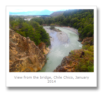
Pretty soon, the Patagonian dry steppe gave way to scenic and verdant rainforest, as we entered the wet region where the Pacific dumps its water as rain, North of the ice cap. With huge forests of lenga beech trees mixed with ferns and broad-leaved Chilean rhubarb, this area was complete mix of Valdivian temperate rainforest and Magellanic sub-polar forests.
We even saw rosa mosqueta which we recognized as being the tea we had in Neuquén when we stayed with Margarita our couchsurfing host. Beautiful pink flowers lined the road like a beautiful natural avenue.


We finally arrived in Tranquilo after over four hours of driving. A small hamlet between Cochrane to the South, and Coihaique to the North, Tranquilo is the destination for people heading off to trek to the ice cap, tour to San Rafael National Park, or, where we were headed, the marble caves.
Andres sorted out an English translator for us – a local lady called Bianca – and we were boarded onto a small motorboat. We headed out over the pretty calm waters (we were really lucky with the weather – the previous night was very windy – a storm in which one Israeli backpacker had lost her life in Cerro Castillo National Reserve, after breaking an ankle and then getting hyperthermia at over 2000 feet).
After about 40 minutes in the boat we saw the first of a series of marble caves along the shore of the Lago General Carrera. Grey, yellow and blue streaked stone formed caves at the water’s edge, where over 6000 years of weathering by the wind and water had eroded the metamorphic rock away to the point where you could park your boat in them. And we did!


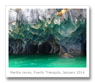
Some of the shapes were awesome – they looked liked natural temples in the water. Smooth rock gave way to dimpled depressions, with some of the edges looking really sharp. The water was very calm still as we explored the caves and took pictures. It would easily have been possible to swim through the caves, or to stand on the rock with the water at ankle height, but it was freezing cold glacial water so we gave it a miss!
The marble actually formed the whole of the coast here including the cliffs on the land. Some of the marble looked like layers had peeled off. Our guide told us this was due to petrified wood being embedded in the marble, but this almost certainly nonsense – it is probably from the wind and rain, and the topography of that particular section.
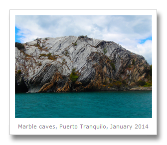
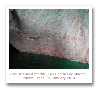
Around the next cove and we found las capillas, the chapels. A smooth section of the marble that formed pillar-like formations, with swirling patterns on the face of the marble, caused by mineral impurities within the rock. The water was so green-blue that it really gave the place a serene and beautiful feel. There was even some pink marble here.
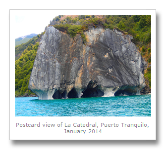
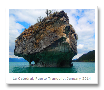
Across from the chapels, was the postcard photo view of the centerpiece of the marble caves – La Catedral de Mármol. This was an island of marble, with beautiful swirling patterned caves at its base, and greenery growing all over it. Some of the caves went straight through the island so you could see through to the other side.


We spent about half an hour at the caves before heading back to shore. The wind had picked up a little bit, and the guy driving the boat was not concentrating at all, so when we hit a hug wave badly, the guy from another couple that were on the boat with us flew up out of his seat and crashed down on the boat on his back. He was not pleased.



After dropping Bianca off at her house, we headed to a lunch spot with Andres. It was a restaurant but it was hard to tell even though there was a small sign outside. Inside it looked like someone’s living room –and it probably was. A Chilean tour group of eight people arrived and we all settled down to a three course lunch of typical Chilean food, which was included in the price of our tour.
First up was a Chilean stew called Carbonada, which had green beans, carrots, potatoes and squash. Rice and beef gave it the substance whilst cumin and oregano gave it flavor. It was delicious and just the thing to warm us up after the windy boat ride.

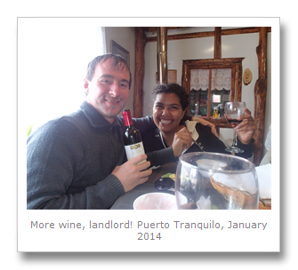
We next had a beef steak with mash and salad, and for dessert we had a red wine semolina pudding. This together with some Chilean Cabernet Sauvignon made for excellent eating, and left us feeling sleepy and satisfied.


On the way back in the truck, we stopped at a different waterfall than the one’s we had already seen. Climbing through a fence we picked our way along a river bank and came across a very loud and very angry kingfisher. It was very upset we were there, possibly because it had a nest in the area, so we left it alone and walked a short distance to the waterfall where a huge tree had fallen in.


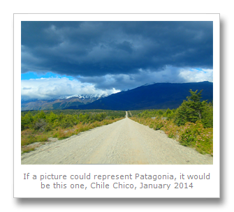
We got back to Chile Chico after about four hours of driving – we had seen rabbits in the road, and gauchos on horseback driving their sheep this way and that.
That night we got a pizza on the main road on the credit card (still no cash), and went to bed. We decided we really needed to get to the district capital, Coihaique (which had the only ATM) and that was across the lake. I bought the tickets for the ferry on the card, but the bus tickets that you also have to buy for the other side did not take card – arrghh! I convinced the ferry people to give me some money after swiping through a transaction, and paid with that, horrible visions of being stuck here going through my min.
We made it up to the windy viewpoint which is on the Western edge of town. It has 210 numbered steps, but is an easy climb. It is located next to where all of the hitchhikers stand, trying to get around the lake.


No-one picks up hitchhikers in this part of the world, though. We saw people on bikes dangerously cycling around the road, and people even walking! Numerous hitchhikers would stand in the middle of the road pleading for us to stop, but there were so many of them, and we had paid for our tour, so we didn’t. It is easy to get stuck down here, it seems.


The viewpoint had some nice views of the lake, mountains and town. It seemed to also carry a slur against the prevalent Israeli tourists that come here in huge groups too – signs to all of the different countries in the world, including Palestine, not Israel. That might explain some of the unfriendly attitudes we had felt before – we think they thought we were Israeli. The groups come here after their stint in the army, and cause all sorts of commotion with their well-known brash and aggressive bad manners.


We finally got on the ferry (it runs at different times each day, confusingly), along with several vehicles and other people. We preyed the wind would stay calm, which it did, so the ferry did not turn back, and we made it across the emerald waters in about two hours to Puerto Ibáñez. This small port on the North shore was where we connected with our bus and continued on with our journey. We were lucky not to get stuck as it seems a lot of people do. This side of the Andes may be a bit more challenging than the other side.